Category: Applications

A Low Cost 2.4 GHz Downconverter from off the Shelf Dev Boards

Over on GitHub Ian Wraith has released his design and microcontroller code for a low cost 2.4 GHz downconverter circuit. A downconverter is a hardware device that shifts the signals that it receives into a lower frequency band. This is useful in the case of RTL-SDRs and Airspy SDRs, as their maximum frequency range is only 1.7 GHz. Ian's 2.4 GHz downconverter reduces those 2.4 GHz signals down to 1 GHz, which can then be received with his Airspy.

Rather than designing a circuit from scratch, Ian's design makes use of several very cheap Chinese evaluation/development boards that he found on eBay. It costs of a mixer board, oscillator board, and an STM32 development board for controlling the oscillator board via SPI. The whole set of hardware cost him less than £30 (~37 USD).

After spending some time working through the difficulties in programming the SPI interface on the STM32 board, he was able to get the downconverter circuit fully working. He notes that he's been able to receive WiFi, Zigbee, Bluetooth and ISM band signals at 2.4 GHz, as well as 3G and 4G cellular signals at 2.6 GHz.

Ian Wraith's Downconverter consisting of three off the shelf cheap Chinese eBay boards.

Upcoming KerberosSDR Software Updates: Automatically Estimate TX Location and Navigate There

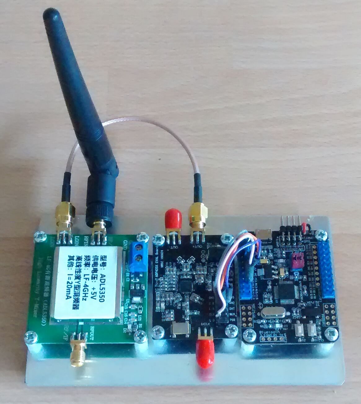
KerberosSDR is our 4x Coherent RTL-SDR that we've developed together with Othernet. It can be used for tasks such as direction finding and passive radar. KerberosSDR was successfully crowdfunded over on Indiegogo, and the first batch has already been shipped. Currently we are taking discounted pre-orders for a second production batch on Indiegogo. Please note that the discounted pricing will expire when we ship, which according to the manufacturing schedule should be next month, so please get in quick if you're interested!

If you'd like to back the KerberosSDR project and purchase a unit, please see our Indiegogo page.

Below are some recent updates to the project:

Android App Software Improvements

The Android App allows a KerberosSDR user to drive around in a car, collecting angle of arrival data for a signal. Driving around and collecting multiple data points solves the multipath issue. In a single location it is possible for a signal's direction of arrival to be skewed or incorrect as it can bounce off multiple surfaces and appear to be arriving from a wrong direction. If we collect data from many locations, we can average out the multipath.

We've recently been working on improvements to the direction finding capabilities of the KerberosSDR, and in particular to our free Android App which records and plots data from the KerberosSDR server. We are still testing and finalizing these new features, but hope to release the updated app before the end of this month.

Recently added features to the app include:

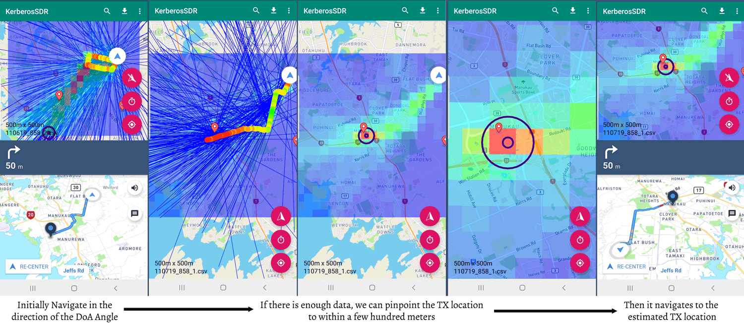
  • Added the ability to determine the estimated location of a transmitter, providing there has been sufficient data collected.
  • Added a heatmap grid of the collected data which can be used to determine where most angle lines cross. Can take into account RF power data too.
  • Added the ability for the software to automatically navigate you to the estimated TX location via MapBox GPS turn by turn navigation.

Bellow are screenshots showing some of the new features. In this experiment we located an 858 MHz TETRA transmit tower. Initially the app will navigate you to the edge of the grid, in the direction that most DoA lines are pointing to. When there is sufficient data to be able to confidently pinpoint the TX location, it will begin navigating you to the estimated location. In the screenshots the placemarker represents the known location of the transmitter, and the circles indicate the location estimated from direction finding.

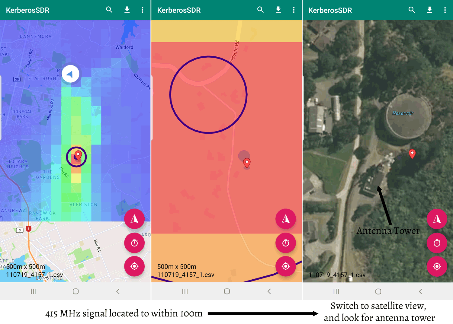
Below is screenshots from a 415 MHz DMR tower that we located with KerberosSDR. The antenna array was purposely kept small, with a diameter of only 12cm. Even with the small antenna array we were able to pinpoint the transmitter down to about 100 - 200 meters.

The app should also now be able to handle intermittent signals, via a squelch filtering function, although this has not been fully tested yet.

In order to navigate you must have a 3G/4G data plan on your phone, and your phone must have the ability to create a WiFi hotspot. The KerberosSDR server running on a Pi 3 or similar will then automatically connect to a WiFi hotspot named "KerberosSDR" running on your phone and provide data to the app via WiFi.

Batch 2 Manufacturing Updates

Batch 2 production is in full swing, and at the moment we're expecting completion by mid August. This batch will ship directly from China, so we should be able to ship them off fairly quickly rather than needing to first wait for them to arrive in the USA.

Magnetic Whip Antennas

We have been disappointed that it has been difficult to find low cost but good quality magnetic whip antennas to use with KerberosSDR and vehicles. The quality of antennas used in direction finding equipment can matter, as any signals leaking into the coax, or radiation pattern skew can affect results. We are working on sourcing some high quality magnetic whip antennas that have good ground coupling. These will be sold at a reasonable price on our store.

Future Updates

We are still working on improving the server software further too and future updates will include things like the ability to notch out unwanted signals during phase calibration, a simplified DoA set up wizard, an improved buffering scheme so that additional data and processing gain can be applied, and more.

The Raspberry Pi 4 looks to be an excellent candidate to be used with the KerberosSDR. We will begin releasing ready to use images for the Pi 4 in the future.

Thanks!

Every sale of a KerberosSDR helps fund further developments to the software and possible future iterations of the hardware. So we'd like to thank all backers once again!

rtlSpectrum: A New GUI for rtl_power

Thank you to Andrey for submitting news about the release of his new open source program called "rtlSpectrum". rtlSpectrum is a GUI for rtl_power, which allows you to scan a wide swath of bandwidth with an RTL-SDR dongle. The scan can then be plotted with rtlSpectrum, and peaks of activity can then be determined. Some of the features include:

  • load from .csv file produced by rtl_power
  • run rtl_power directly. it should be available in the $PATH
  • add multiple graphs for analysis
  • subtract one graph from another
  • save/export graph in the rtl_power based format

In particular, the ability to subtract one graph from another is useful for analyzing filters. Andrey has posted about doing this with rtlSpectrum, a noise source and an RTL-SDR V3 over on his blog (note that the blog is in Russian, so please use Google Translate if necessary). He notes how the dynamic range of the RTL-SDR is limited, so that the true blocking power of a filter cannot be determined, but it is enough to see the shape and frequency response.

rtlSpectrum Screenshots

Two Antenna Diversity For the SDRPlay RSPDuo now Available in SDRUno

The SDRplay RSPDuo is a 14-bit dual tuner software defined radio capable of tuning between 1 kHz - 2 GHz. It's defining feature is that it has two receivers in one radio, which should allow for interesting phase coherent applications such as diversity.

In the latest v1.32 release of SDRUno a diversity feature has been added. Diversity reception was demo'd back in May at Hamvention, and we have a previous post with video about that. Diversity works by subtracting or adding two signals from the two receivers running independent antennas. The result is an up to 3 dB increase in SNR, and better performance with fading signals. They write:

From V1.32 onwards, MRC (Maximal Ratio Combining) Diversity is supported using the RSPduo. MRC Diversity can be used to combine the 2 tuner input streams together to potentially improved the SNR (signal to noise ratio). The same frequency is used for both tuners in the RSPduo and the gain can be adjusted either on each tuner independently or locked together (the default method).

Diversity mode is enabled by clicking on the RSPduo MODE dropdown and select DIVERSITY. Make sure both the 50 ohm ports are connected to the correct input source and note that the HiZ port is not available for Diversity mode. Trying to use the HiZ port will result in an error message being displayed.

Diversity Controls in SDRUno

Meteor M N2-2 Successfully Launched: Awaiting LRPT Signal

On July 5 the Russian Meteor M N2-2 weather satellite was successfully launched into orbit and appears to be healthy. The LRPT weather camera signal is not yet broadcasting however, and we expect it to still take roughly 1-2 months before it begins (if all goes well) as satellites typically run through a long list of qualification tests before becoming operational. During this time there may be broadcasts of test patterns that can be caught. Meteor M N2-2 can currently be tracked in Orbitron and online at N2YO.

To try and dispel any confusion over the naming scheme, "Meteor M N2" is the currently operational LRPT satellite. "Meteor M N2-1" unfortunately failed in 2017 as it did not separate from the rocket. "Meteor M N2-2" is the new satellite which has just been successfully launched. Meteor M N2 and M N2-2 is often abbreviated as just "Meteor M2" and "Meteor M2-2". In the past there was Meteor M N1, but this satellite is no longer operational. We have upcoming launches for Meteor M2-3, M2-4, MP-1 and M3 to look forward to which are scheduled for 2020 and 2021.

Back on June 28 we posted about how Meteor M2 was experiencing orientation issues for a few days. Those issues appear to have been rectified now. Hopefully if M2 remains stable we'll have two Meteor LRPT weather satellites to receive alongside the three NOAA APT satellites.

If you're interested, there were also several other payloads onboard the rocket carrying M2-2, including a low cost Czech experimental cubesat called Lucky7 whose telemetry can be received in the amateur radio band at 437.525 MHz. There is an onboard camera too, but no details on how to receive it yet.

Soyuz Rocket carrying Meteor M2-2 Launched successfully. [Source: spaceflightnow]

Solar Sail Satellite Lightsail-2 Now Transmitting Morse Code Beacon

Lightsail-2 is a solar sail experiment which successfully launched on a Space-X Falcon Heavy on 25 June, and was released into orbit on July 2nd. A solar sail is a type of spacecraft that uses a large metallic foil to create propulsion via photons from the sun hitting it. Lightsail-2 is still undergoing testing, so it has not yet deployed it's solar sail, but recent updates indicate that it is healthy.

On board Lightsail-2 is a radio which is transmitting it's morse code beacon "WM9XPA" every 45 seconds at 437.025 MHz. This beacon should be able to be received with a handheld amateur radio 70cm Yagi and any radio such as an RTL-SDR. There is also an AX.25 telemetry data transmission, however although the beacon structure is available we are not aware of any publicly available decoding software.

One difficulty in receiving Lightsail-2 is that it is in an orbit inclination of only 24 degrees. So only locations with a latitude between 42 and -42 degrees will have a chance at receiving it. You can see the solar sail's current location at N2YO. Clicking on the 10-day predictions button will give you pass predictions for your location.

Estimated Lightsail-2 Viewing Range
Lightsail-2 Deployed

SignalsEverywhere: Investigating USGS Gaging Stations and their GOES Satellite Connection

The United States Geological Service maintains over 8500 "Gaging stations" in bodies of water all over the country. Gaging stations are devices that are used to measure environmental data such as groundwater levels, discharge, water chemistry, and water temperature. What's interesting is that they all upload their data in real time to GOES satellites - the same satellites that we can use with an RTL-SDR to receive weather images of the entire earth. The data is then downlinked in the L-band to the USGS scientists via a protocol known as DCP (Data Collection Platform).

In the latest SignalsEverywhere video, Corrosive investigates how these stations work, and how we can receive the downlink at 1.68 GHz with a simple Inmarsat L-band antenna. While a fully functional decoder is not yet available, Corrosive notes that one called goes-dcs is currently being worked on.

USGS Gaging Station | Satellite Uplink to GOES and DCP Messages

Tracking Company Jets with ADS-B to Give an Edge to Hedge Fund Investors

Financial news site Bloomberg recently ran an article about how hedge fund managers are using ADS-B to track private company aircraft in order to help predict the next megadeal between companies. They explain with an example:

In April, a stock research firm told clients that a Gulfstream V owned by Houston-based Occidental Petroleum Corp. had been spotted at an Omaha airport. The immediate speculation was that Occidental executives were negotiating with Buffett’s Berkshire Hathaway Inc. to get financial help in their $38 billion offer for rival Anadarko Petroleum Corp. Two days later, Buffett announced a $10 billion investment in Occidental.

There’s some evidence that aircraft-tracking can be used to get an early read on corporate news. A 2018 paper from security researchers at the University of Oxford and Switzerland’s federal Science and Technology department, tracked aircraft from three dozen public companies and identified seven instances of mergers-and-acquisitions activity. “It probably shouldn’t be your prime source of investing information, but as a feeder, as an alert of something else what might be going on, that’s where this work might be useful,” says Matthew Smith, a researcher at Oxford’s computer science department and one of the authors.

"Alternative data" collection firms like Quandl Inc. have services like "corporate aviation intelligence", where they use ADS-B data to keep tabs on private aircraft, then sell their data on to hedge funds and other investors who are hoping to gain an edge in the stock market.

Popular flight tracking sites that aggregate ADS-B data like FlightAware and FlightRadar24 censor data from private jets on their public maps upon the request of the owner, but it's not known if they continue to sell private jet data on to other parties. ADS-B Exchange is one ADS-B aggregator that promises to never censor flights, however the data is only free for non-commercial use. The value from using companies like Quandl is that they probably have a much more accurate database of who each private jet belongs to.

The Bloomberg article also mentions another use case for tracking private flights, which is  tracking the movements of known dictators via their private jets. We previously posted an article about this too. We've also in the past seen ADS-B data used to track world leaders, and help United Nations advisers track flights suspected of violating an arms embargo.

ADS-B data is typically collected these days with a low cost SDR like the RTL-SDR. We have a tutorial on setting up your own ADS-B home tracker here.

Features of Quandl Inc's Corporate Aviation Intelligence Service.