Category: RTL-SDR

KerberosSDR: Tracking Aircraft on a Map via Passive Radar and Beamforming Only (Future Code Demonstration)

If you've been following KerberosSDR development (our US$149 4 channel coherent RTL-SDR), then you'll know that one interesting experiment that you can set up with it is a passive radar. Passive radar makes use of already exiting strong transmitters that broadcast signals such as FM, DAB and HDTV.

With one directional antenna pointing towards the transmitter, and one pointing in the general direction of moving objects like aircraft, it's possible to detect the transmitted signal being reflected off the aircraft's body.From the time delay and doppler shift detected in the reflected signal, a simple distance/speed plot showing the aircraft in motion can be created. This previous post shows an example of what information you could potentially collect in a range/speed graph over time. In the past we've also used passive radar to detect vehicles and measure how much traffic is in a neighbourhood.

However, with two antennas we can only get the detected object's range and distance information. If we use four antennas (one pointing towards the transmitter, and three pointing in the direction of objects), it is possible to use beam forming techniques combined to obtain an estimated map coordinate of the object. This is possible as we then we have distance information available from the passive radar algorithm, and bearing information available from the beam forming algorithm.

Tamas Peto who wrote our open source KerberosSDR code has been working on some new upcoming features for the KerberosSDR software, and beamformed direction finding of passive radar is one of them.  We note that to be clear this software is not yet released, and we still expect there to be several months before it is ready. At the moment all data was processed manually offline after collecting data with a KerberosSDR as part of this early test.

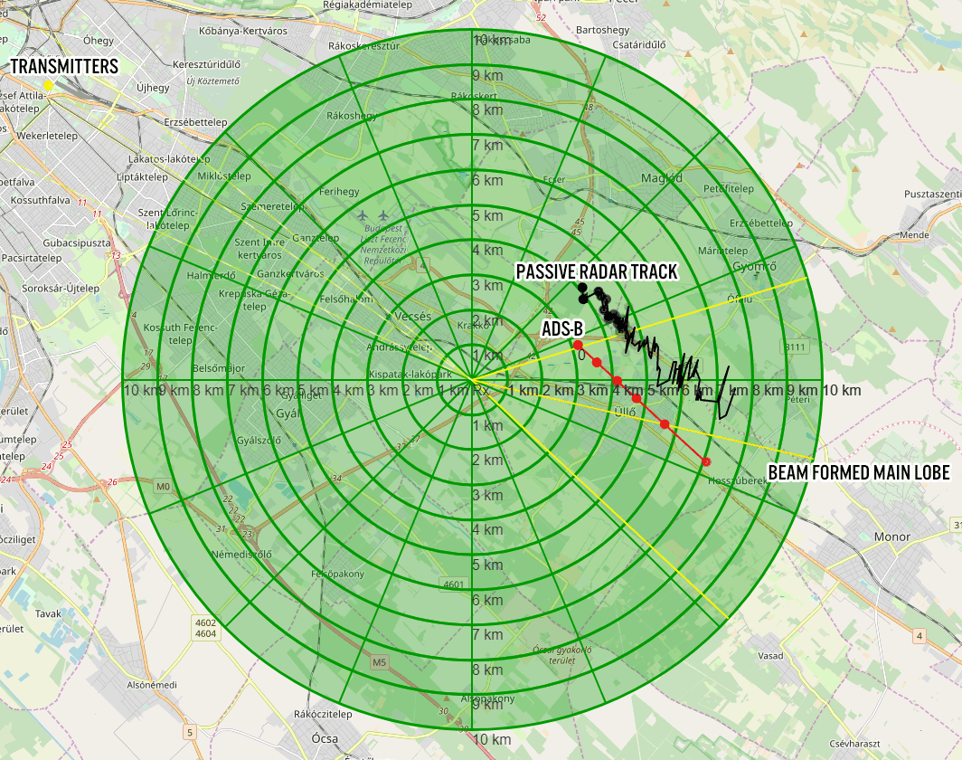
The image below shows an example of a recent measurement made from an aircraft. The red tracks show the actual ADS-B GPS coordinates of the aircraft, and the black line indicates the positional data measured from a DAB signal reflecting off the aircraft body. The orange line to the east indicates the main lobe of the three beam formed directional antennas, and the lines to the west indicate transmit towers.

The measured trajectory is only about 1-2 km off the actual one. Tamas notes that the position offset may be because at the moment altitude is not measured yet.

If you're interested in more information, Tamas created a PowerPoint presentation which can be downloaded from our Google Drive.

Passive Radar with Beamforming and Direction Finding

Other upcoming features that are planned for the KebrerosSDR code include being able to use direction finding on short bursty signals, improvements to networked direction finding and beamforming which may be useful for applications like radio astronomy and performance improvements.

KerberosSDR can be purchased from the Othernet store or Hacker Warehouse, and every purchase helps us fund development of more interesting features like passive radar beamforming!

MEMESat-1: A Meme-Beaming Cubesat Currently In Development

The Mission for Education and Multimedia Engagement Satellite (MEMESat-1) is planned to be the first meme broadcasting cube satellite ever created. If you aren't down with modern slang and are not familiar with the word "meme", that may be because although first coined in 1976, the modern definition was only added to the Webster-Miriam dictionary in 2015. In the traditional sense a meme is a cultural idea, behavior, style that people can't help but want to share because of how funny/amusing/interesting it is.

But in particular MEMESat-1 wants to broadcast from space the new type of meme definition, which is essentially funny or amusing images/GIFs that internet users and especially youth like to modify and share online through social media. Memes have become a major part of internet youth culture, so this could be an excellent way to speak the language of the next generation and get them interested in space, satellites, amateur radio and building satellite ground stations.

At the moment, the team hopes to launch the satellite by late 2021, and no later than Spring 2022. The satellite will be a cubesat with flash memory containing thousands of meme images that will be broadcast to Earth via a transmitter operating in the UHF 70cm radio band. Enthusiasts on the ground will be able to receive the meme images with a Yagi antenna and we anticipate that RTL-SDRs will be a commonly used receiver. The satellite will also contain an FM UHF/VHF repeater operating in the amateur radio band for ham radio use.

MEMESAT-1 is being developed by letsgo2space.com, a non-profit trying to increase the exposure kids have to STEM topics. Over on Reddit, the founder explains his story and mission:

I went out and started a nonprofit organization, built a website, developed a meme-related anxiety disorder, and am now building a meme-beaming satellite with a group of undergrads at UGA and some industry sponsors. And it’s all for the sake of making a novel meme. We are now fundraising to launch MEMESat-1.

For those who are interested in reading about the trials and tribulations of a 22 year old man-child trying to send memes into space, I’ve included the longer story below.

For my whole university career, I was in search of different work opportunities and internships to see what felt the most fulfilling and to get some of those sweet sweet resume lines. I’ve interned at a plastic factory, the Air Force Research Labs, NASA JPL, and Ball Aerospace. They were all great places filled with awesome people and cool work, but I didn’t feel connected with my work in a way that fulfilled me. So, for the past 3 years me and my buddies have been joking around about building a satellite that beams down memes from space.

Enter MEMESat-1.

While I was working at JPL, me and some buddies got together to toy around with space start-up ideas. We joked more about MEMESat, and bought the memesat.com domain back in 2018. Due to timing and other life events the start-up idea kind of fell off. One of my pals is pursuing his Ph.D, and the other is working as a spacecraft engineer full-time. I on the other hand, still had 2.5 years of school left.

Work on the MEMESat concept slowly came to a halt by the end of 2018, but picked up again in Spring 2019 when I came up with the acronym the Mission for Education and Multimedia Engagement Satellite (MEMESat-1). I kept telling my classmates and friends about the project idea as a joke, but they thought I was being serious and told me to go for it. By May 2019 I had worked out a deal with some universities to use their space, and began building the website. Over that summer, my job left me some spare time, so I started ramping up the social media for MEMESat-1 by posting daily spacefacts to instagram. I also worked on some preliminary design studies to see if the mission would be feasible, and decided that it definitely was. I also spent the summer researching how to form a company, and what the best company structure would be.

In August 2019, I returned to school and began to work on forming a company. Some great profs at GT gave me the advice to start a nonprofit, so I searched for some pro bono legal advice on starting a nonprofit. I took some of the lawyer’s advice and found some willing Directors for the company, and filed to form a nonprofit corporation - called Let’s Go to Space, Inc.

Around that time, I posted to reddit and got a bunch of attention from you guys, so I figured I should work my hardest to make it happen. I spent months emailing every space related company I could find or even think of. I have much more respect now for people that lead telemarketing campaigns, because it is really hard to convince random people over the phone/email to give you large sums of money. Now, I am happily partnered with Ball Aerospace and sponsored by Blue Canyon Technologies. I’m also in talks with some launch providers about a free launch and some help launching my lesson plans/experiment kits to classrooms all over!

We have passed the point of no return and have nowhere to go but upwards. My parents are confused and slightly disappointed that their rocket scientist son has given up any sort of salary in an effort to appease his ‘internet friends’. God bless you magnificent weirdos for keeping me going. Ad Astra Per Memes.

Currently letsgo2space is fundraising and looking for $30,000 to fund the launch of MEMESAT-1. You can either donate any amount or submit a meme for their broadcast database for $1.69 via their website.

MEMESat-1 Logo
MEMESat-1 Logo

Driver Patch for FC0013 RTL-SDRs Improves UHF and ADS-B Performance

Thank you to Benjamin Larsson for submitting news about a FC0013 tuner patch he's submitted for the Osmocom RTL-SDR driver code. FC0013 based RTL-SDRs have been relatively unpopular due to the reduced tuning range of only 22 - 1100 MHz, compared to the larger 24 - 1766 Mhz range provided by the R820T2 chip. However, they have been found in some cheaper units.

Benjamin's patch reportedly improves UHF performance above 862 MHz, and also seems to make ADS-B reception usable.

The patch was submitted to the Osmocom GitHub, however, this Git is not monitored as Osmocom have their own patch submission system via mailing list. But if you have a FC0013 dongle and want to try it, the entire change consists of only a single register value change which could easily be manually modified in the driver code before compilation. 

Register change to improve UHF performance on FC0013 RTL-SDR dongles.

Look4Sat: An Android App for Tracking and Predicting Amateur Radio and Weather Satellite Passes

Thank you to Arty Bishop for submitting news about his recently released Android App called Look4Sat. Look4Sat is a satellite tracker and pass predictor with a focus on amateur radio and weather satellites. The app is free, ad free, and open source on GitHub.  Arty writes that he's programmed this as a learning exercise and notes:

I always wanted to have an offline and not bloated satellite tracker on my phone, as carrying the laptop at all times is kinda not too handy.

The app uses predict4java library under the hood and is written in Kotlin. The TLE files are from Celestrak and the transmitters info is from SatNOGS and once they are  ownloaded the app doesn't need an internet connection.

The app creation and design is hugely inspired by Gpredict which is an absolutely brilliant piece of software. Thank you, Alexandru!

Obviously there is no ads and it's totally free. Hope more people find Look4Sat useful.

The features include:

  • Calculating satellite passes for up to one week (168 hours)
  • Calculating passes for the current or manually entered location
  • Showing the list of currently active and upcoming satellite passes
  • Showing the active pass progress, polar trajectory and transceivers info
  • Showing the satellite positional data, footprint and ground track on a map
  • Offline first: pass prediction is done offline. It's up to you to decide when
    to update the TLE file and the transceivers DB. (Updates once a week are recommended)
Look4Sat Android App Screenshots

Shazam Style Automatic Signal Identification via the Sigidwiki Database

Thank you to José Carlos Rueda for submitting news about his work on converting a "Shazam"-like Python program made originally for song identification into a program that can be used to automatically identify radio signals based on their demodulated audio sounds. Shazam is a popular app for smartphones that can pull up the name of any song playing within seconds via the microphone. It works by using audio fingerprinting algorithms and a database of stored song fingerprints.

Using similar algorithm to Shazam, programmer Joseph Balikuddembe created an open source program called "audio_recogition_system" [sic] which was designed for creating your own audio fingerprint databases out of any mp3 files.

José then had the clever idea to take the database of signal sounds from sigidwiki.com, and create an identification database of signal sounds for audio_recogition_system. He writes that from his database the program can now identify up to 350 known signals from the sigidwiki database. His page contains the installation instructions and a link to download his premade database. The software can identify via audio that is input from the PC microphone/virtual audio cable or from a file.

Fingerprinted Audio Samples of Radio Signals

Cheap and Easy Hydrogen Line Radio Astronomy with an RTL-SDR, WiFi Parabolic Grid Dish, LNA and SDRSharp

We've recently been testing methods to help budding amateur radio astronomers get into the hobby cheaply and easily. We have found that a low cost 2.4 GHz 100 cm x 60 cm parabolic WiFi grid antenna, combined with an RTL-SDR and LNA is sufficient to detect the hydrogen line peak and doppler shifts of the galactic plane. This means that you can create backyard hydrogen line radio telescope for less than US$200, with no complicated construction required.

If you don't know what the hydrogen line is, we'll explain it here. Hydrogen atoms randomly emit photons at a wavelength of 21cm (1420.4058 MHz). Normally a single hydrogen atom will only very rarely emit a photon, but the galaxy and even empty space is filled with many hydrogen atoms, so the average effect is an observable RF power spike at ~1420.4058 MHz. By pointing a radio telescope at the night sky and averaging the RF power over time, a power spike indicating the hydrogen line can be observed in a frequency spectrum plot. This can be used for some interesting experiments, for example you could measure the size and shape of our galaxy. Thicker areas of the galaxy will have more hydrogen and thus a larger spike, whereas the spike will be significantly smaller when pointing at empty space. You can also measure the rotational speed of our galaxy by noting the frequency doppler shift.

The 2.4 GHz parabolic WiFi grid dishes can be found for a cheap at US$49.99 on eBay and for around US$75 on Amazon. Outside of the USA they are typically carried by local wireless communications stores or the local eBay/Amazon equivalent. If you're buying one, be sure to get the 2.4 GHz version and NOT the 5 GHz version. If you can find 1.9 GHz parabolic grid dish, then this is also a good choice. Although we haven't tested it, this larger 2.4 GHz grid dish would probably also work and give slightly better results. WiFi grid antennas have been commonly used for GOES and GK-2A geosynchronous weather satellite reception at 2.4 GHz with RTL-SDRs as well and we have a tutorial on that available on our previous post.

These dishes are linearly polarized but that is okay as hydrogen line emissions are randomly polarized. Ideally we would have a dual polarization (NOT circular polarized) feed, but linear appears to be enough and is much simpler. In addition, the 2.4 GHz feed is obviously not designed for 1420 MHz, but just like with GOES at 1.7 GHz the SWR is low enough that it still works.

The animation below shows a hydrogen line "drift" scan performed with the 2.4 GHz WiFi dish, an RTL-SDR Blog V3 and a NooElec SAWBird H1 LNA. The scan is performed over one day, and we simply let the rotation of the earth allow the Milky Way to drift over the antenna. The Stellarium software on the left shows the movement of the Milky Way/galactic plane over the course of a day for our location. The dish antenna points straight up into the sky, and we have set Stellarium to look straight up too, so Stellarium sees exactly what our dish antenna is seeing.


You can clearly see that there is a lump in the radio spectrum at around 1420.40 MHz that grows when parts of the Milky Way pass over the antenna. This lump is the hydrogen line being detected. As our Milky Way galaxy is filled with significantly more hydrogen than empty space, we see a larger lump when the antenna points at the Milky Way, and only a very small lump when it points away.

It's important to ignore the very narrowband spikes in the spectrum. These narrowband spikes are simply radio interference from electronics from neighbors - probably TVs or monitors as we note that most of the interference occurs during the day. There is also a large constant spike which appears to be an artifact of the LNA. The LNA we used has a 1420 MHz filter built in, but LCD TVs and other electronics in today's suburban environment spew noise all across the spectrum, even at 1420 MHz.

You can also note that the hydrogen line peak is moving around in frequency as different parts of the galaxy pass overhead. This indicates the doppler shift of the part of the galaxy being observed. Because the arms of the galaxy and the hydrogen in it is rotating at significant speeds, the frequency is doppler shifted relative to us.

Using the power and doppler shift data of the hydrogen line is how astronomers first determined the properties of our galaxy like shape, size and rotational speed. If we continued to scan the sky over a few months, we could eventually build up a full map of our galaxy, like what CCERA have done as explained in this previous post.

Continue reading

A FM Radio Passive Radar System from Two RTL-SDR Dongles

Over on his blog, Max Manning has posted about his senior year design project which was an RTL-SDR based passive radar system that he created with his project partner Derek Capone. Max's writeup explains what passive radar is, and how the theory works in a very easy to understand way, utilizing graphs and short animations to help with the understanding. The rest of the post then goes into some deeper math, which is also fully explained.

Passive Radar works by using already existing powerful transmitters such as those for TV/FM. A receiver listens for these signals being reflected off of objects like aircraft and vehicles, and compares the reflection with a signal received directly from the transmitter. From this information a speed/range graph of detected objects can be calculated

For hardware, the team used two RTL-SDR dongles with the local oscillators connected together. A standard dipole is used as the reference antenna, and a 5-element Yagi is used as the surveillance antenna.

Max's post is a great read for those trying to understand how to do passive radar with a KerberosSDR which is our 4x coherent input RTL-SDR unit available from the Othernet store or Hacker warehouse. Being a radio capable of coherency, it is useful for applications like passive radar and direction finding. 

Their code is all open source and available on GitHub. We note that their code should also work with KerberosSDR with only either zero to minor modifications required. However, for the KerberosSDR we also have our own passive radar code available which might be a little easier to setup via the GUI.

Passive Radar with Two RTL-SDR dongles sharing a single clock.

How to Not Break Your SDR + Other Articles from oneSDR

A new software defined radio blog called onesdr.com has recently posted a useful article for radio world newbies called "How Not to Break your Software-defined Radio Hardware". The article goes over a few important precautions like avoiding input power which is too high from transmitters and LNAs, avoiding DC input, and avoiding ESD.

They've also uploaded a few other articles that may be useful like "What is a Bias Tee?", "FM Notch Filters – why you need one with most SDRs", "What to look for when buying a Software-Defined Radio (SDR)", "Should I place a Low Noise Amplifier Before or After a Filter?", "The Best Software-Defined Radios (SDRs) for 2020" as well as several more.