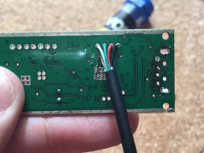
Rodrigo's system consists of an IF tap amplifier+filter board that is connected to an internally mounted RTL-SDR. The RTL-SDR is internally connected to the FT-991A's USB hub which had to be upgraded from a 2-port hub to a 4-port hub as the 2-ports were already in use by the CAT and Audio features. This required the stock USB hub IC to be replaced with a hot air rework station.
Everything is mounted inside the radio chassis itself, and the end result is a neat solution with no external wires, hubs or dongles that has essentially turned the FT-991A into an SDR. Plugging in the single stock USB cable from the FT-991A results in the standard CAT and Audio interfaces showing up, as well as the RTL-SDR.
What's also interesting is that Rodrigo makes use of the GPIO pins on our RTL-SDR Blog V3 to enable the RX_EN, BPF and BYPASS switches on the IF tap board. This allows for a cleaner solution as no external switches need to be installed.
The entire project is open source with schematics and the BOM provided over on the GitHub, and excellent documentation is available on the project's Wiki.
FT991A Converted into an SDR.
Turning FT-991A to a REAL SDR: Embedding a SDR Panadapter INSIDE the radio, no extra wires!
This week on the SignalsEverywhere YouTube channel Harold shows us the mobile SDR and ham radio setup that he's installed on his car. On the roof of his car he's installed several antennas for various amateur radio bands including the 1.25m, 2m, 70cm, 33cm bands, a modified GPS puck antenna for Inmarsat and Iridium reception, and an antenna and GPS pick dedicated for APRS.
Inside the vehicle is a Windows tablet attached to the dashboard which is used for APRS, remotely controlling a scanner radio stored in the trunk and for running SDRSharp. There is also an Android unit installed in the center console which has an RTL-SDR connected. The Android unit runs RF Analyzer, and an ADS-B decoder. As well as SDRs, Harold also runs several standard ham radios within the vehicle.
Amateur Radio Mobile SDR Load Out | SDR Plus 33cm 70cm 2m 1.25m and more!
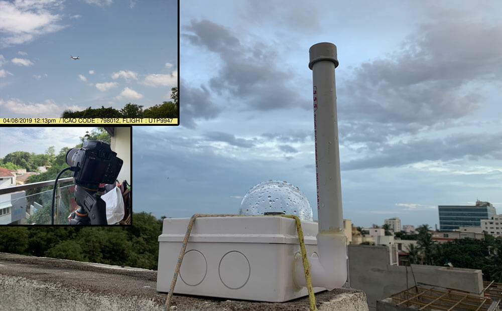
Arun Venkataswamy has recently completed a write up about his system which automatically captures images of passing aircraft. It works by using a Raspberry Pi and RTL-SDR to listen to ADS-B broadcasts from aircraft. These broadcasts contain the live current location and altitude of all aircraft in his area. When a landing aircraft is detected to be passing near his house, the Raspberry Pi sends a signal to another Raspberry Pi connected to a camera on his balcony, and that snaps a photo of the passing aircraft.
In terms of software, Arun uses dump1090 as the ADS-B decoder. For communications between the two Raspberry Pi's he uses Node-RED and Mosquitto in order to communicate with MQTT. On the second Raspberry Pi, gPhoto2 captures images from the camera, and then ImageMagick is used to write some text about the aircraft and photo on the image. Arun's post goes in further detail about the code and conditions he uses to determine when a photo should be snapped.
In the past we've posted about a similar project where an RTL-SDR and Raspberry Pi based ADS-B tracker was used with a servo mounted video camera to track and record video of passing aircraft.
Automatically Taking Photos of Passing Aircraft with a Raspberry Pi and RTL-SDR
SDR-Kits.net have begun selling low cost GPS antennas that are modified to receive the Inmarsat satellite frequencies between 1535 MHz to 1550 MHz. They also have a version for Iridium satellites that receives 1610 MHz to 1630 MHz. The antennas are powered by a 3-5V bias tee, so they should work fine with SDRplay, Airspy and RTL-SDR Blog V3 units.
AERO messages are a form of satellite ACARS, and typically contain short messages from aircraft. It is also possible to receive AERO audio calls. STD-C aka FleetNET and SafetyNET is a marine service that broadcasts messages that typically contain text information such as search and rescue (SAR) and coast guard messages as well as news, weather and incident reports. Some private messages are also seen. To decode AERO Mike uses JAERO, and for STD-C he uses the Tekmanoid STD-C decoder.
Mike has also created a very handy bank of frequencies for the SDRUno frequency manager which can be downloaded from here.
We note that if you're interested in waiting, at the end of September we will have an L-band patch antenna set available too. Our antenna will work from 1525 up to 1637 MHz. Prototypes have shown have shown good Inmarsat, Iridium and GPS reception. More details coming next month when manufacturing gets closer to finishing up.
Screenshot of the Tekmanoid Decoder from Mikes Tutorial
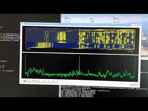
Over on GitHub user mcogoni (Marco/IS0KYB) has recently released a new program called Pepyscope. Pepyscope is a simple and fast panadapter application that is designed to be used with direct sampling capable RTL-SDR's such as our RTL-SDR Blog V3 units. Like other panadapters you simply connect the IF output from the hardware HF radio into the input of the RTL-SDR. Then Pepyscope gives you a waterfall display that helps users to easily visualize the spectrum.
Pepyscope is open source and runs on Linux PCs. So far Marco has tested Pepyscope with a KENWOOD TS-180S (single conversion with IF at 8.83 MHz) and an RTL-SDR v3. He has also uploaded a demonstration video on YouTube.
PEPYSCOPE: a simple panadapter for Linux and the RTL-SDR in direct sampling mode
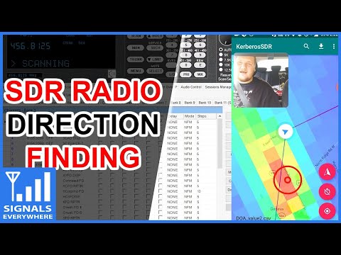
On this weeks episode of SignalsEverywhere, host Corrosive tests out our KerberosSDR coherent RTL-SDR unit for radio direction finding. If you didn't already know KerberosSDR is our experimental 4x Coherent RTL-SDR product. With it, coherent applications like radio direction finding (RDF) and passive radar are possible. Together with the KerberosSDR direction finding Android app it is possible to visualize the direction finding data produced by a KerberosSDR running on a Pi3/Tinkerboard.
In the video Corrosive uses the KerberosSDR together with the recently updated companion Android app to determine the location of a P25 control channel. By driving around with the app constantly collecting data he's able to pinpoint the location within about 15 minutes.
In addition to his video, Corrosive has also created a very useful calculator that can be used to calculate the required antenna spacing for a circular or linear direction finding array that can be used with the KerberosSDR.
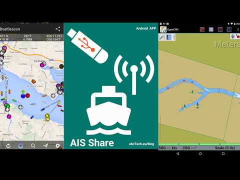
Thank you to Christian, programmer of the AIS Share Android App for letting us know about some updates to his AIS Share Android application. AIS Share is a €2 app for Android that allows you to turn an Android device into an AIS receiver together with an RTL-SDR. AIS stands for Automatic Identification System and is used by ships to broadcast their GPS locations in order to help avoid collisions and aide with rescues. An RTL-SDR with the right software can be used to receive and decode these signals, and plot ship positions on a map.
Recent updates to AIS Share have brought improved AIS reception, and updates allowing it to run on the latest Android version. A new video demonstrating the software was also uploaded to YouTube.
AIS SHARE - Android (RTL-SDR AIS receiver)
The App has also been featured in the February 2019 edition the "Practical Boat Owner" magazine (paid magazine with digital editions). The article discusses using AIS Share and an RTL-SDR to stream data to Boat Beacon, which is a popular chart navigation app. A similar but free tutorial on setting up AIS Share and Boat Beacon can be found here.
An excerpt of the Practical Boat Owner AIS Share RTL-SDR Article.
GOES 16/17 and GK-2A are geosynchronous weather satellites that transmit high resolution weather images and data. In particular they are far enough away from the earth to be able to take beautiful 'full disk' images which show the entirety of one side of the Earth. As these satellites are in a geosynchronous orbit, they can be counted on to be in the same position in the sky at all times, so no tracking hardware is required and images can be pulled down constantly throughout the day without having to wait for a polar orbiting satellite to pass over like you would with the NOAA APT or Russian Meteor satellites.
With a low cost WiFi grid dish antenna, LNA and RTL-SDR dongle, any home user within the footprint of one of these weather satellites can receive and decode live images directly from the sky. Setting up a station is overall not too difficult, but it can be a bit fiddly with a number of steps to complete. Below is our comprehensive guide. We'll show how to set up a self contained Raspberry Pi based system with goestools (free), as well as a guide for the Windows PC software XRIT decoder (US$125).
We've attempted to make the tutorial as newbie friendly as possible, but we do need to assume basic RF knowledge (know what antennas, SDRs, coaxial, adapters etc are), basic Linux competency for the goestools tutorial (using the terminal, using nano text editor), and basic Windows competency for the XRIT decoder tutorial (unzipping, editing text files, running programs).
A full disk false color image received directly from the GOES-17 satellite with an RTL-SDR. Click for the full size image (14MB).
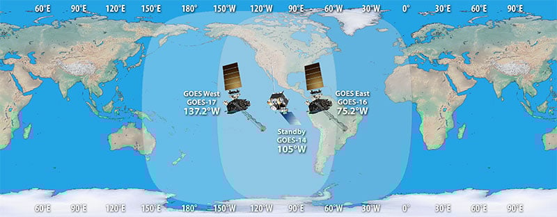
There are two fourth generation NOAA GOES satellites that are currently active, GOES-16 and GOES-17. These transmit HRIT signals, and also transmit shared data from the older third generation GOES 15, and Japanese Himiwari8 satellites. At the moment GOES-16 and GOES-17 are producing full disk images every 30 minutes, and close up "mesoscale" shots of the USA every ~15 minutes. GOES-16 (aka GOES-R) and GOES-17 (aka GOES-S) are also known as GOES-EAST and GOES-WEST respectively. At least one of these satellites can be received from North/South America, Canada, Alaska/Hawaii, New Zealand, Eastern Australia and some pacific islands.
There is also the older generation GOES-15 and GOES-14 which have been placed in standby orbits. These transmit LRIT signals which provide images at a slower rate.
GOES 16/East and GOES 17/West Signal Footprint
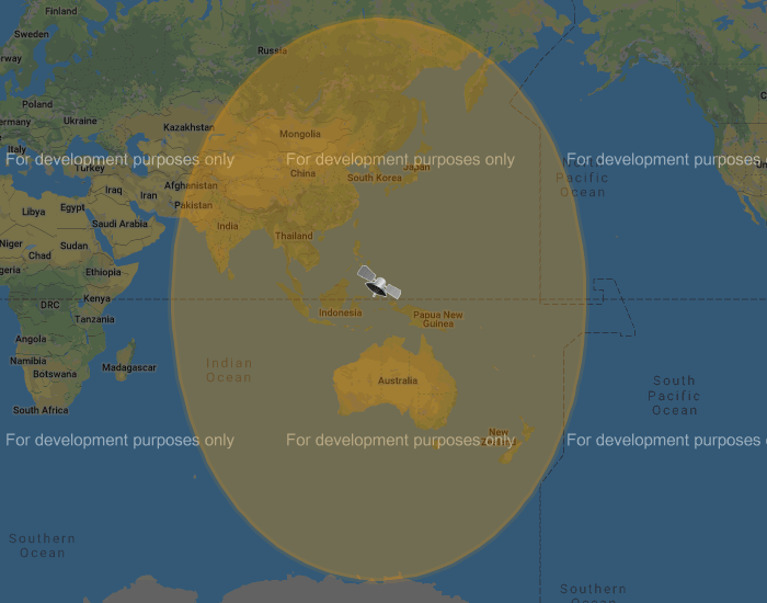
There is also the Korean GK-2A (GEO-KOMPSAT-2A) satellite which is very similar to the GOES satellites. GK-2A covers countries like India, Asia, Australia, New Zealand and parts of Russia. Note that you may have previously heard of the COMS-1 satellite which used to cover this area. Since July 2019 COMS-1 was replaced by GK-2A. Unlike GOES, GK-2A images are encrypted. However it has been found that "sample" encryption keys found online in demo code work just fine.
GK-2A contains both LRIT and HRIT channels, but at the moment only the LRIT channel can be decoded with the currently available software. The LRIT channel sends full disk IR images every 10 minutes in 2200 x 2200 resolution. Compared to the 5424 x 5424 resolution GOES full disk images, this is smaller, but still large enough to be interesting.
Note that even if HRIT decoding is added by the current software, you would require an Airspy or other wideband SDR as the GK-2A HRIT signal bandwidth is 5 MHz. Also since the HRIT bandwidth is so wide, the signal strength is reduced, meaning that you'll need a larger dish. People who have received the HRIT signal note that a 3M+ sized dish seems to be required.
GK-21 (GEO-KOMPSAT-2A) Footprint
You might ask why bother receiving these satellite images directly, when you can get the exact same images from NOAA at https://www.star.nesdis.noaa.gov/GOES/index.php. Well, you might want to set up your own station to be independent from the internet, or you live in a remote location without internet, or maybe just for the fun and learning of it.
To set up a receiver for GOES 16/17 HRIT or GK-2A LRIT you'll need to purchase a dish antenna such as a cheap 2.4 GHz WiFi antenna, an RTL-SDR, GOES LNA, and a Raspberry Pi if using goestools, otherwise a Windows PC can be used. The total cost could be anywhere from $150 - $200 depending on what pieces you already have available.
Before we start the tutorial, you might want to use an augmented reality Android app like "Satellite-AR" to get a rough idea of where either GOES 16/17 or GK-2A (GEO-KOMPSAT-2A) is in your sky, and if receiving them is even feasible for your location. You'll need to find an area on your land where you can mount a small satellite dish with an unobstructed line of sight view to the satellite (no trees or buildings can be blocking the signal path). If the satellite is low on the horizon (below 25 deg elevation), then things get a little more difficult as you have more obstructions and a weaker signal. But it can still be done, and we're able to routinely get good results at 24.5 deg elevation.
Note that for Europe and Africa, unfortunately there are no satellites that can be received easily with an SDR and LNA. But you might instead be interested in the EUMETCAST service, which can be received from EUTELSAT 10A (Ku band), Eutelsat 5 WEST A (C Band) and SES-6 (C Band) . To receive this service you'll need a DVB-S2 receiver and a satellite dish with appropriate band LNB. You also need a license keys and software which all together cost €100. EUMETCAST reception is not covered in this tutorial, instead see this video.