Category: Satellite

Open-Weather: Contribute to a Snapshot of the Climate Crisis Through NOAA Satellite Imagery

Open-weather is an art project made up of a community of volunteers who capture NOAA weather satellite images with RTL-SDR or similar devices. The images are then collected and stitched together to form a snapshot of the planet, and to be used in various art projects. We have previously posted about some related art projects that the team behind open-weather have done in the past.

Receiving NOAA satellite images may now be run of the mill for many of us technically minded people who have been in this hobby for a while, but one of the ideas behind open-weather is to reach out and inspire people from any background to try and receive satellite weather images. This includes people and communities in the arts that may not be technically minded at all. To achieve this the team has created easy to understand guides, hosted workshops, and created artwork and performances based around the reception of these satellite images.

In a recent article on theconversation.com, the team describe how they collected 38 images from 29 volunteers, across 14 countries and six continents on the first day of the COP26 climate conference. By involving more people in the process of essentially watching the earth from afar, they hope to inspire climate responsibility and to put some thought behind how we are affecting and being affected by the changing environment. An excerpt from the article is pasted below:

This snapshot included a cyclonic weather system curling around the UK, dust clouds sweeping the Indian subcontinent, and the glaciers of the Patagonian Andes, which have been shown by geographer Bethan Davies to be rapidly receding and thinning in response to global warming.

...
 

These satellite images and field notes demonstrate that the climate crisis feels different depending on who you are and where you live. In some places, dry seasons are expanding. Elsewhere, it’s clouds of dust, increasingly volatile storms, or health effects triggered by the air that we breathe.

As politicians fail to respond to the climate emergency, a growing community of Earth-watchers has practical and political potential. Together, we might learn to be collectively responsible for, and accountable to, the environments we are changing.

Sasha Engelmann of Open-Weather receives a NOAA Satellite Image.

Radio Related News Occurring in the Russia-Ukraine Conflict

In the current Russia-Ukraine conflict we've seen several noteworthy radio related events occurring over the last few days, mostly throughout Twitter.

Russian HF Bomber Communications

As mentioned in the previous post it has been found that since the start of the invasion, Russian Strategic bombers have been very active on USB voice at 8131 kHz. We've even seen a security firm predict air raid siren activations based on increased bomber HF activity. 

Russian Military HF Frequencies Jammed by Activists

It has been observed that several Russian military HF stations including the famous UVB-76 Buzzer have been jammed with either the Ukrainian national anthem, or various meme-type songs. It is likely that these stations are being jammed mostly by civilian activists, or members of the activist hacker collective known as Anonymous, rather than any military organization.

The UVB-76 Buzzer is a famous and mysterious numbers station that plays a buzzing sound and sometimes voice. It can be received from all over the world. Via civilian investigations, and through the use of the KiwiSDR TDoA direction finding functionality, it has been found to be transmitted from a location just north of St. Petersburg, and is assumed to be a military signal of some sort.

We've also seen waterfall text based jamming:

Using KiwiSDRs you can listen to these jammed stations yourself remotely through public internet connected SDRs in Europe. Some known frequencies are listed here and here

We note that there have also been reports about fake Russian frequencies being posted on the internet.

We assume most jamming is happening from outside the warring countries, and it is unknown how far the jamming signals extend onto Russian or Ukrainian territory, or how much of an impact they are having on Russian operations.

Russian State TV Hacked

Twitter account Anonymous TV has reported hacking Russian state TV to show citizens what is actually happening in Ukraine. It's unknown if this was a hack via TV transmissions being overpowered by another signal, or a computer hack.

Starlink Activated in Ukraine

A few days ago Elon Musk and SpaceX activated their Starlink wireless satellite internet system in Ukraine, and have sent over a shipment of ground terminals. This is useful as even if the local wired internet were to be destroyed, or be censored by Russia, the Starlink system will be able to connect to uncensored internet as long as there is power. 

An account of a Ukrainian engineer and RF hobbyist recently Tweeted his success at getting his Starlink system up and running from his home in Ukraine. We decided not to link to his Twitter account in this post, just in case he needs to delete his account for safety in the future as he appears to be very close to the bombing.

Viasat Satellite Service Experiences Cyberattack and Outages

Viasat, another provider of satellite internet services in Ukraine region appears to have been subject to a DDOS cyberattack, causing outages to it's satellite internet service in the European region.

SSTV Activism Seen On Russian Meridian Satellites

Meridian satellites are a "family of telecommunications satellites for civil and military use developed by Russia in the 2000s placed in a Molniya Orbit" (Wikipedia). A tweet by Scott Tilley @coastal8049 has noted that they have seen reports of SSTV activist activity occurring on the 484 MHz Meridian transponders. 

Scott Tilleys Twitter feed also shows some interesting other pieces of news and information, including frequencies and orbits of Meridian satellites, images of a destroyed Russian command and control satellite communications vehicle, and links to now deleted, but Google cached pages with information about Russian satellite communication systems.

APRS Activism against Russia causes APRS-IS DDOS

Amateur radio operators can use a system called APRS to communicate with text and packet data globally through internet connected radio repeaters. A few days ago it appears that anti-Russia activists flooded the APRS-IS (Automatic Packet Reporting System-Internet Service) system with bogus packets targeting Russian coordinates, which unintentionally resulted in a denial of service (DOS) event on APRS trackers like aprs.fi

DARC Urges Safety First for Ukraine and Foreign Amateur Radio Hobbyists

The German ham-radio association known as DARC has issued a warning to Ukrainian hams, and to foreign hams who may receive from them. Amateur radio operations are currently banned in Ukraine due to wartime laws.

Poland Amateur Radio Society Provides WinLink HF Email Service

In response to geopolitical threats, the Poland Amateur Radio Society has set up a HF WinLink email system, aimed at provided email services to amateur radio operators that could be cutoff from internet email services. It appears this may be aimed at helping Ukrainians communicate, however in these modern days of electronic warfare, it is important to take into account the warning from DARC above too as transmitting stations could easily be located by Russian electronic warfare forces.

Dear HAM operators, in the face of the latest threats in our region and a possibility of an incoming wave of refugees, with over 2 mln already living in Poland, we would like to remind you that we are at your disposal.

If you are a licensed amateur radio operator, you can send information by e-mail to your relatives in Poland or Emergency Services with via the Winlink system, which works on HF bands, independently of access to the local ICT infrastructure https://winlink.org/WinlinkExpress.

We advise you to download the software, install it and check its operation.
Polish WinLink nodes are QRV on 160,80,20m
SR5WLK dial frequency 3595,5 kHz USB
SR3WLK dial requency 14111 kHz USB
SP3IEW dial frequency 1865 kHz USB

If we receive information about the cut-off of the Internet in the region in danger, we will be QRV daily as SP0MASR @ 18-20 UTC on the frequencies 3770 kHz +/- QRM, 7110 kHz +/- QRM. In such a situation, please communicate in Polish or English.

We are here to serve you.

Shortwave Listening Updates

The excellent SWLing.com blog has also provided some updates on shortwave, including news that WRMI have resumed broadcasts of Radio Ukraine International, Ukrainian state radio resumes broadcasting at 549 kHz, and that the BBC adds to new broadcasts to Ukraine.

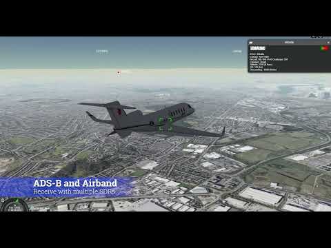
Russian Oligarch Jets Tracked with ADS-B

An activist has set up a Twitter account to track the private jets of Russian Oligarch's via ADS-B. ADS-B aircraft data can be used to track aircraft locations, and these signals are typically received with low cost SDRs like RTL-SDRs. The project appears to use data sourced from adsbexchange.com which is known to be one of the only ADS-B aggrators that does not censor data.

The 7055 kHz 'Radio War' Frequency Sees Increase in Activity

In has been reported that the 7055 kHz LSB amateur radio frequency has been used by Ukrainian and Russian amateur radio operators for some time now to insult each other in a 'radio war', and recently activity has significantly increased. Other frequencies involved include 7050 kHz LSB and 3731 kHz.

Captured Equipment Shows Russian Radio Hardware In Use

A recent tweet shows a photo of hardware supposedly captured from Russian forces. Of interested is a Russian R-187PI Azart, a handheld digital software defined radio.

At the same time unconfirmed reports suggest that some parts of the Russian army may be relying on civilian Baofeng radios.

Global Area Coverage (GAC) Images Decoded from NOAA Satellites

Thank you to @ZSztanga and @aang254 for submitting news about their recent success at decoding the L-Band Global Area Coverage (GAC) signal from polar orbiting NOAA satellites. GAC images are low resolution, and described by NOAA as follows:

Global Area Coverage (GAC) data set is reduced resolution image data that is processed onboard the satellite taking only one line out of every three and averaging every four of five adjacent samples along the scan line.

While it's low resolution, the interesting thing about this data is that you get an image of the entire orbit, not just the data from your current location as you'd receive with the standard 137 MHz APT or L-Band HRPT signal. The catch is that the signal is usually only transmitted over the USA, and you'll need a motorized or hand tracked L-Band satellite dish setup to receive it.

We note that GAC data is not to be confused with the Direct Sounding Broadcast (DSB) signal decoding software we posted about in 2020. 

@ZSztanga has provided some more information about what images are available and who can receive it, and @aang254's tweet below provides some images and additional information:

With @aang254 we decoded GAC from NOAA satellites. It's basically a dump of reduced resolution data from the whole orbit. It includes all the instruments and is transmitted on L-band along with HRPT (mostly over USA, rarely above Europe and only NOAA-19 dumps outside the US). All the decoders are in SatDump.

There is also a schedule available (https://noaasis.noaa.gov/cemscs/polrschd.txt) that includes all the dumps in the upcoming week. It might be a bit hard to interpret, but basically there is a date and the ground station name (SVL stands for Svalbard and it is the only one receivable in Europe). Entries with "GAC" or "PBK" are referring to the GAC transmission.

We've also seen a tweet by @OK9UWU that shows a much longer image of a full orbit.

Demonstrating the New 3D Maps in SDRAngel

In December of last year we posted about a video demonstrating the many features that the SDRAngel software comes standard with. Recently they've added a new feature which are 3D maps that can be used to visualize signal data.

In the latest video demonstration they show these 3D maps projecting NOAA weather satellite images onto a 3D globe and at the same time tracking the NOAA satellites over the globe as it produces imagery. They also show the software visualizing a 3D model of aircraft on the globe, using live ADS-B data to show aircraft maneuvers when taking off, cruising and landing. With multiple SDRs they also show how the visualization can be combined with air traffic voice. Finally they also show marine vessels being visualized via live AIS data. There appear to be a wide range of vessel 3D models implemented.

A List of Crowd Sourced SDR Data Exchanges

Over on Reddit u/onemindisbuddha has put together an interesting list highlighting the number of crowd sourced data aggregators that use RTL-SDRs or similar hardware.

A common example of a data aggregator that makes use of RTL-SDRs is most of the flight tracking websites, such as FlightAware and FlightRadar24. Contributors to the service will usually set up RTL-SDR + Raspberry Pi based receivers that feed ADS-B aircraft data received from the local area to these websites. Data from contributors from all over the world are then combined onto a single map, allowing for a global live picture of aircraft traffic.  

Some other examples on the list that use RTL-SDRs include Amateur Radio APRS tracking, marine traffic, police/EMS audio feeds, train traffic, weather audio feeds, satellite ground station feeds and general web based remote SDR access. Added to the list are also aggregators based on other devices for applications like lightning detection and seismic activity reporting.

Aggregators List Partial Screenshot

Receiving X-Band Images from the Arktika-M1 Arctic Monitoring Satellite

Recently on Twitter @arvedviehweger (Arved) has tweeted that he has successfully received images from the Russian Arctic monitoring satellite known as ARKTIKA-M1, via it's X-band downlink at 7865 MHz. We've reached out to Arved and he's provided the following information on his setup and how he's receiving and decoding the images.


The Arktika-M1 satellite is a Russian weather satellite which operates in a HEO orbit. It was launched in February 2021 and has downlinks on multiple bands. The main payload downlink for the imagery is on 7865 MHz (which is also known as the lower X-Band). The satellite only transmits imagery on the X-Band at the moment, it is currently unknown whether it will ever transmit any image data on L-Band.

For Amateur reception that means having access to X-Band RF gear. It usually consists of a low noise pre-amplifier and a downconverter to convert 7865 MHz down to a lower frequency for easier reception with a high bandwidth SDR such as the LimeSDR, a USRP etc.

In my personal setup I use a surplus pre-amplifier made by MITEQ (around 36dB of gain, 1dB NF), my own self-made DK5AV compact X-Band downconverter and a LimeSDR-USB.

The L-Band gear is mounted on top (helix and the pre-amp behind it) and the X-Band gear is right below. From left to right you can see the feed, the downconverter (silver box) and the LNA (mounted to a heatsink and a fan). Recording is done with a LimeSDR-USB running at a sample rate of 50 MSPS. The satellite transmits every 15 minutes once it reaches its apogee, each transmission including the idle period lasts for about 10 minutes. Some pictures of the idle transmission and the actual data transmission can be found in this Tweet, [noting that Idle = more spikes, actual data looks weaker]:

Depending on the geographical location a rather large satellite dish is also required for Arktika-M1. Reception reports all over Europe clearly show that the satellite has a beamed antenna (similar to ELEKTRO-L2).

In my setup I can get away with a 2.4m prime focus dish (made by Channel Master) in North Eastern Germany. It produces around 9 - 10 dB of SNR in the demod of @aang254’s excellent SatDump software. Anything above 5dB will usually result in a decode but since the satellite does not have any FEC you will need more than that for a clean picture. (Image of SNR in Satdump)

A Comprehensive Beginners Guide to HRPT Weather Satellite Reception

Over on his blog Derek (OK9SGC) has recently uploaded a very comprehensive beginners guide to receiving HRPT weather satellite images. HRPT reception can be a little daunting as it requires a good L-Band dish setup which involves choosing and building a feed, and importantly, a way to track the satellite with the dish as it moves across the sky. Tracking can be achieved manually by hand, but that can be very difficult and so a motorized tracking mount is recommended.  

This is unlike the much easier to receive NOAA APT or Meteor LRPT satellite signals in the VHF band which can be received by a V-dipole antenna, or the geostationary GOES HRIT satellites that can be received with a WiFi grid dish and LNA. Both of which do not require tracking.

The advantage of HRPT however, is that you end up with high resolution, close-up, and uncompressed images of the earth. For example Derek notes that NOAA APT gives 4km/px resolution, and Meteor LRPT gives much better 1km/px resolution but it is heavily compressed. Whereas HRPT gives peak resolutions of 1km/px uncompressed. There are also nine satellites in operation sending HRPT, so there are more opportunities to receive.

Derek has created a very comprehensive beginners guide that covers almost everything from purchasing and building the hardware, to finding and tracking the satellites, to setting up the software and decoding images. He notes that an RTL-SDR can be used as the receiver, and that a WiFi dish with GOES SAWBird LNA can work, although the difficult tracking requirements are still there so a smaller offset dish with custom helix feed might be preferred. Derek also provides useful tips, like the fact that the NOAA15 HRPT signal is quite a lot weaker than others.

Images from Dereks HRPT Guide

Nils Reviews our RTL-SDR Blog L-Band Active Patch Antenna

Over on his blog Nils Schiffhauer (DK8OK) has recently uploaded a review of our RTL-SDR Blog Active L-Band Patch Antenna. This is a satellite patch antenna designed for experimenters who want to receive Inmarsat, Iridium, GPS and other GNSS signals. It covers 1525 - 1660 MHz. (Please note it does not cover GOES or other L-band weather satellites as these are much weaker signals that require a dish). The antenna comes as a set with mounting hardware and extension cable and can be purchased on our store for $49.95 including free worldwide shipping to most countries.

In his review Nils tests the patch antenna with his wideband BladeRF software defined radio showing a wide 60 MHz of bandwidth being received. He then goes on to show it being used to receive AERO, via the JAERO decoder, and STD-C via the Tekmanoid decoder.

We want to take this opportunity to pre-announce that due to rising shipping costs the price of this antenna set will be going up by $10 in early 2022. Before the price raise we will put out another post, but if you are interested in one we'd recommend picking one up soon.

Nils tests the water resistance of the antenna.