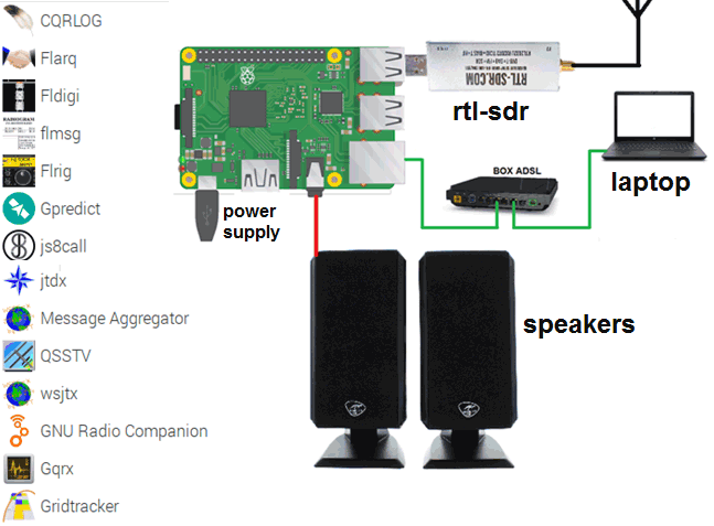
Over on his blog F4GOH has posted a rather comprehensive tutorial consisting of seven PDF documents showing how he's set up his Raspberry Pi for ham radio and other RF projects. The PDF's essentially form a book that starts with the very basics like preparing an OS for the Pi SD Card, powering on the Pi, finding the IP address and connecting to it with SSH or VNC.
The tutorials move on to installing and using various ham radio programs like Fldigi, WSJT-X , GQRX, GNU Radio, before going on to teach some more Linux concepts. The final two PDF tutorials cover the installation and use of OpenWebRX for remote RTL-SDR use, R2Cloud for decoding weather satellites, and finally Radiosonde Auto RX for decoding radiosonde's on weather balloons.
Over on his YouTube channel Tech Minds has uploaded a video showing how it's possible to receive and decode GPS signals with an RTL-SDR. To do this he uses one of our RTL-SDR Blog V3 dongles and a GPS patch antenna which is powered via the bias tee on the dongle.
On the software side he uses GNSS-SDRLIB and RTKLIB to decode the GPS signal. The result of the two programs is your current GPS coordinates which can be plotted on a map. Unfortunately in the video Tech Minds was unable to get the Google Maps display to work, but you can easily type the coordinates into Google maps yourself.
A few weeks ago we posted about the recently uploaded talks listed on the Defcon YouTube channel. However, there is a second YouTube channel dedicated to talks presented as part of the Defcon Aerospace Village which was also held virtually. A number of these talks involve software defined radios and RTL-SDRs and so may be of interest to readers. We have listed a few interesting talks below, but the full list can be found on their YouTube channel.
A Deeper Dive into ILS and ADS-B Spoofing - Harshad Sathaye discusses weaknesses in the security of the Instrument Landing System and ADS-B and how these can be spoofed.
Introduction to ACARS - Alex Lomas explains aircraft ACARS text messages in detail and discusses receiving them with an RTL-SDR
Low-Cost VHF Receiver - Alan Tart, Fabian Landis show how to build a low cost VHF airband receiver from an RTL-SDR, Raspberry Pi and the RTLSDR-Airband software.
With an RTL-SDR, an appropriate satellite antenna and LNA it is possible to receive visible light images from geostationary satellites such as GOES/Himawari and GK-2A. However, in a 24 hour cycle there will only be one or two images that show the Earth fully illuminated by the sun. The rest of the day parts or all of the Earth will be dark with not even clouds visible. To get around this the satellites also use an Infrared (IR) camera which can see clouds at all times. However, these images are greyscale and not very visually appealing.
To fix this aesthetic issue there is now a recently released multiplatform tool called "Sanchez" which will combine a high resolution underlay image with the greyscale IR image in order to create a more beautiful image. The software is command line based and can run on a batch of collected images.
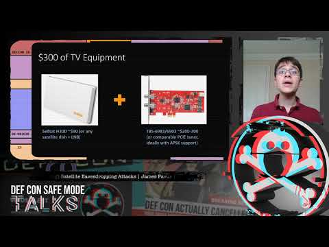
DEFCON 2020 was held online this year in and the talks were released a few days ago on their website and on YouTube. If you weren't already aware Defcon is a major yearly conference all about information security, and some of the talks deal with wireless and SDR topics. We found two very interesting SDR and wireless related talks that we have highlighted below. The first talk investigates using commercial satellite TV receivers to eavesdrop on satellite internet communications. The second discusses using a bladeRF or USRP to detect fake 4G cellphone basestations. Slides for these talks are available on the Defcon Media server under the presentations folder.
DEF CON Safe Mode - James Pavur - Whispers Among the Stars
Space is changing. The number of satellites in orbit will increase from around 2,000 today to more than 15,000 by 2030. This briefing provides a practical look at the considerations an attacker may take when targeting satellite broadband communications networks. Using $300 of widely available home television equipment I show that it is possible to intercept deeply sensitive data transmitted on satellite links by some of the world's largest organizations.
The talk follows a series of case studies looking at satellite communications affecting three domains: air, land, and sea. From home satellite broadband customers, to wind farms, to oil tankers and aircraft, I show how satellite eavesdroppers can threaten privacy and communications security. Beyond eavesdropping, I also discuss how, under certain conditions, this inexpensive hardware can be used to hijack active sessions over the satellite link.
The talk concludes by presenting new open source tools we have developed to help researchers seeking to improve satellite communications security and individual satellite customers looking to encrypt their traffic.
The talk assumes no background in satellite communications or cryptography but will be most interesting to researchers interested in tackling further unsolved security challenges in outer space.
DEF CON Safe Mode - James Pavur - Whispers Among the Stars
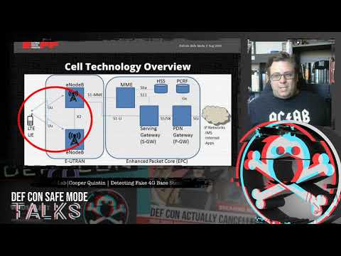
DEF CON Safe Mode - Cooper Quintin - Detecting Fake 4G Base Stations in Real Time
4G based IMSI catchers such as the Hailstorm are becoming more popular with governments and law enforcement around the world, as well as spies, and even criminals. Until now IMSI catcher detection has focused on 2G IMSI catchers such as the Stingray which are quickly falling out of favor.
In this talk we will tell you how 4G IMSI Catchers might work to the best of our knowledge, and what they can and can't do. We demonstrate a brand new software project to detect fake 4G base stations, with open source software and relatively cheap hardware. And finally we will present a comprehensive plan to dramatically limit the capabilities of IMSI catchers (with the long term goal of making them useless once and for all).
Thank you to John D for writing in and letting us know that Wired magazine has recently run an article about the "Nyansat" project. Nyansat aims to bring low cost open source satellite ground stations to the masses. The goal is to democratize citizen access to space by allowing for easier collection of satellite data, or even for collaborative citizen science radio astronomy projects such as the detection of space debris or undocumented satellites. John writes:
While most people think of a satellite ground station as a giant dish mounted on top of a building in the desert, technically any radio receiver that tunes into a satellite's signal can be called a ground station. Somewhere between the giant dish and the GPS chip in your phone is a ground station that uses a directional antenna to pull in the faint signals. So unless you're only interested in geosynchronous satellites, the antenna needs to be aimed at the satellite, and that's where NyanSat comes in.
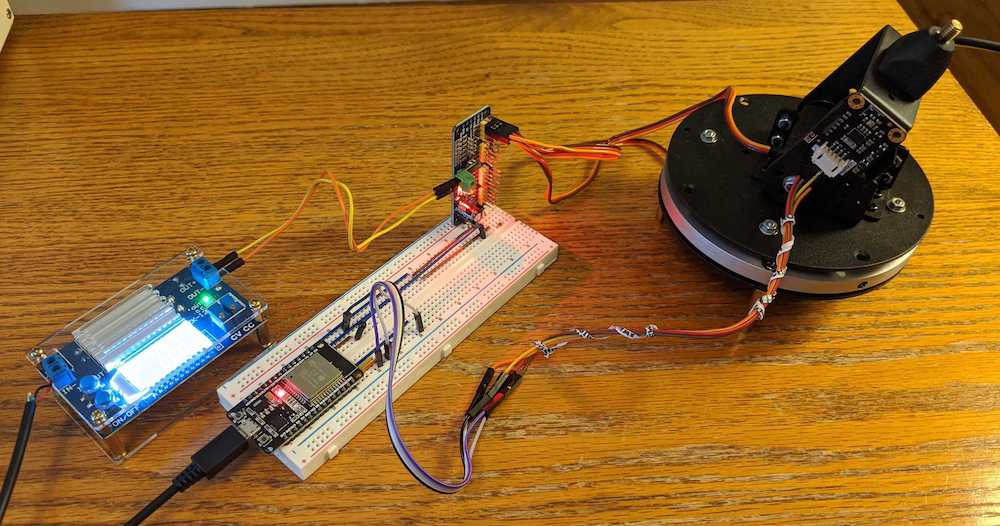
The design of the NyanSat consists of a pan-tilt head, an Inertial Measurement Unit (IMU) for precise azimuth and elevation measurements, a motor-driver board, an optional OLED display, an optional GPS module, and is powered by an ESP32. Full source code is available in their git repo, found at https://github.com/RedBalloonShenanigans/antenny. The NyanSat's software is written in micropython specifically for the ESP32, but obviously could be ported if desired.
Mounting an antenna, adding an RTL-SDR, and actually tuning in a satellite, is still up to the builder.
One of the goals of the NyanSat project is to eventually build up a network of ground stations that can collaborate to contribute frequently updated satellite ephemeris information.
When they're in stock, the project's sponsor, Red Balloon Security, has occasionally been offering a kit containing a custom PCB that is pre-populated with the ESP32 and motor driver; a pan-tilt gimbal; an IMU; and an RTL-SDR. They've been selling them for $1.00(!), just to get them out in the hands of people. Keep your eye open in case they get another batch in.
The Red Balloon store lists the kit as currently out of stock so we suggest keeping an eye on their store just in case any of the $1 kits come back in stock.
NyanSat will also present a live twitch demo at this years online DefCon conference on Friday Aug 7 6:30-8PM EDT and Sat Aug 8 6:30-8PM EDT. On Sun Aug 9 12:30 EDT they will hold another event where they judge the best work of the Nyansat community.
The SatNOGS project which we have covered many times before on this blog is quite similar with it's own open source antenna rotator design, however the Nyansat design looks a bit easier to build as it doesn't require 3D printed parts. Although critically from their demos we haven't seen what sort of sized antennas the gimbal chosen by Nyansat is capable of moving.
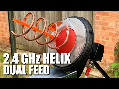
The Bullseye LNB that we have in our store is great for receiving the QO-100 amateur geostationary radio satellite which is available in some parts of the world. However it cannot be used to transmit to the satellite. Over on his YouTube channel Tech Minds shows us how to build a transmit helix antenna that connects to the Bullseye or other suitable LNB, resulting in a dual feed antenna.
The antenna that was built is based on DO8PAT's "Ice Cone Feed" design. The design requires some 3D printed parts for the mount and housing, as well as a copper wire helix, metal reflector and copper matching strip. The Bullseye fits onto the back of the helix mount. Once mounted on a dish Tech Minds shows that he was able to make contact with a friend via the QO-100 satellite with good signal strength.
MetOp and FengYun-3 are both polar orbiting satellites that beam back high resolution weather satellite images. Unlike the NOAA polar orbiting satellites which transmit both the easy to receive APT and more advanced HRPT signal, these only transmit a HRPT signal at ~1.70 GHz, so a satellite dish and motorized tracking mount (or hand tracked) is required. You will also need an SDR capable of receiving over 3 MHz bandwidth such as an Airspy Mini or R2. Alan writes:
I recently got FengYun decoding working after the release of my MetOp decoder a while ago. Since gr-hrpt wasn't usable for Windows user without some major hassle, I made some standalone decoders (Windows builds included in the repo) for both MetOp and FengYun.
Decoding is done by first demodulating with the included flowcharts or @petermeteor's, then processed through the decoder which does Viterbi / Differential decoding. The output then needs to be deframed by MetFy3x or any other software that can do so.
FY-3B HRPT decoded with @aang254 's new decoder. I have to train at tracking a little more for the FY! Also used CLAHE to help the contrast. pic.twitter.com/dZ4ACNOBry