Category: Satellite

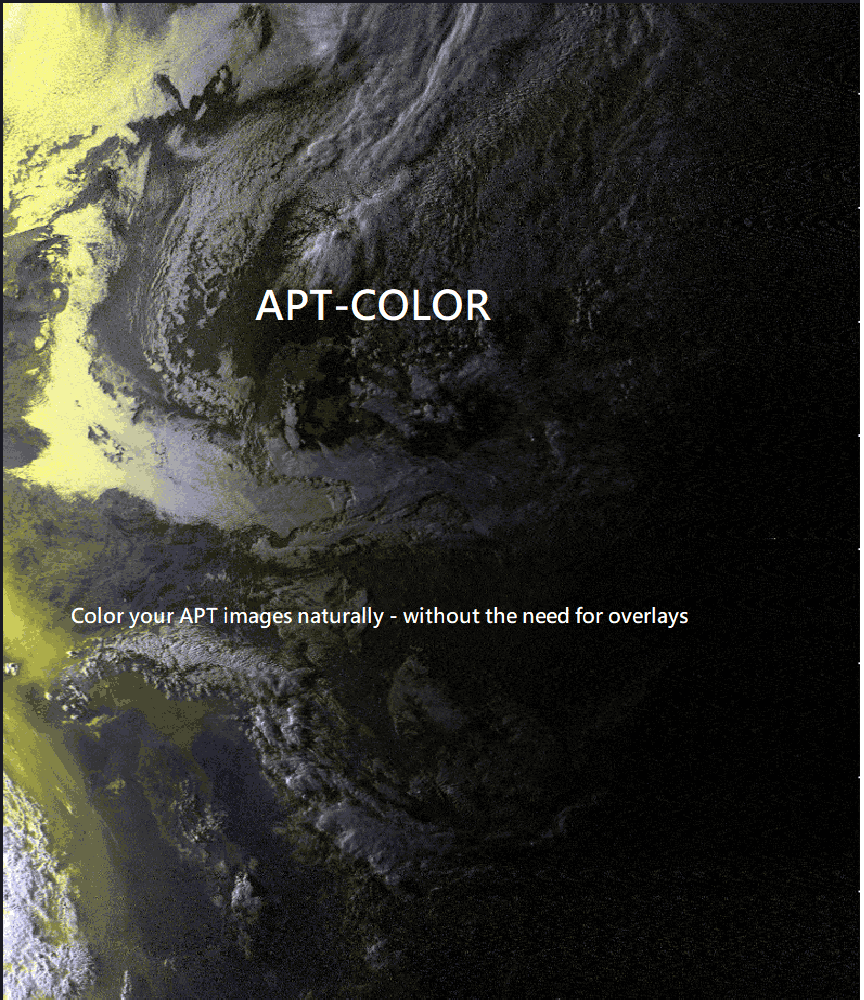
APT_COLOR: Add False Color to Black and White NOAA APT Images

Thank you to Sasha for submitting news about the release of their latest application called "apt_color". The most popular application for decoding APT weather satellite images from NOAA polar orbiting satellites is WXtoIMG. However, WXtoIMG is closed source and is abandonware. There are APT decoder alternatives, however unlike WXtoIMG most other open source APT decoders only provide black and white images, and do not have a false color feature.

The apt_color application can be used to turn black and white APT images received from NOAA satellites into false color images. Sasha writes:

I am working on an APT false color application here. The application is still in the very, very, early stages but still seems to produce good results. It does not need to rely on any overlays, it simply works off the data you give it - the original decoded image data. I will attach some results. NOAA-18 seems to be the best suited spacecraft for this program.

apt_color: Turn black and white NOAA images into false color
apt_color: Examples

SelfieStick: Combining noisy signals from multiple NOAA APT satellites for clean imagery

Researchers from Carnegie Mellon University have recently presented a paper detailing how they combined noisy signals from multiple passes of low earth orbit (LEO) satellites NOAA 15, NOAA 18 and NOAA 19 in order to create a higher quality image. For a receiver they used a low cost RTL-SDR Blog V3 mounted indoors with a whip antenna.

In a normal setup, weather satellite images from NOAA LEO weather satellites can be received with an RTL-SDR, computing device and an appropriate outdoor mounted antenna that has a good view of the sky. If the antenna is not suited for satellite reception, and/or is mounted indoors, at best only poor quality very noisy images can be received.  

The researchers demonstrate that it is possible to combine noisy images received over time, and from different satellites in order to generate a higher quality image. The challenge is that the different satellites and different receiving times will all produce different images, because the satellites will be at a different location in the sky each pass. They note that simply transforming the images in the image domain would not work very well for highly noisy images, so instead they have devised a method to transform the images in the RF domain. The RF signals are then coherently combined before being demodulated into an image.

The results show that 10 noisy satellite images from the indoor system are comparable to one from a comparison outdoor system. However, they note some limitations in that the system assumes unchanging cloud cover during passes. In the future they hope to extend the system to cover other modulation schemes used by other low earth orbit satellites in order to increase the number of usable satellites.

Selfiestick: Combining noisy images from multiple NOAA satellites received by an indoor RTL-SDR system.

TechMinds: Using a LEO Bodnar GPSDO with a PlutoSDR

Over on the TechMinds YouTube channel Matt has been experimenting with using a PlutoSDR for QO-100 amateur radio satellite communications. The PlutoSDR is a low cost RX/TX capable SDR with up to 56 MHz of bandwidth and 70 MHz to 6 GHz frequency range (with mods). The PlutoSDR can suffer from frequency instability, especially when warming up, however on the latest model C/D PlutoSDRs it's possible to inject an external clock signal.

In his video experiment, Matt uses a Leo Bodnar GPSDO as an external clock source. A GPSDO is a "GPS Disciplined Oscillator", as it uses the accurate timing information found in GPS signals to create a high quality clock signal. Matt shows how to set up the GPSDO, and how to tell the PlutoSDR to use the external clock.

He goes on to show the effectiveness of the GPSDO with some transmit experiments.

LEO BODNAR GPSDO With the Adalm Pluto SDR

Lon.TV Demonstrates Decoding Various Digital Signals with RTL-SDR

Tech YouTuber Lon.TV has recently uploaded a video demonstrating how to identify and decode various digital transmissions with an RTL-SDR dongle. In the video he explains how to use VB Cable to pipe audio from SDR# into various decoders, and then goes on to show DMR, APRS, POCSAG, L-Band AERO, FT8, and JS8/JS8CALL all being decoded via an RTL-SDR Blog V3 dongle.

Software Defined Radio Part 2 - Decoding Digital Transmissions with an RTL-SDR USB Radio

SDR# and other Hobbyist Ham Radio Software Spotted in Netflix TV Show Yakamoz S-245

Thanks to all who submitted, we recently received some interesting tip offs about the Netflix TV Show Yakamoz S-245 featuring a scene with various hobbyist SDR and ham radio programs clearly visible. Yakamoz S-245 is a show about a submarine research mission, and the scene appears to depict military intelligence specialists using the programs.

In the scene we've spotted SDR#, MMSSTV, FUNcube dashboard, SATPC-32, and Orbitron. For those interested, the scene is in episode one time 11:20 - 12:00. 

Receiving Analog TV from Turkmenistan Unintentionally Bouncing off a Russian Military Satellite

Over on Twitter @dereksgc has been monitoring the 'Meridian' communications satellites, which are Russian owned and used for civilian and military purposes. The satellites are simple unsecure repeaters, meaning that actually anyone with the hardware can transmit to them, and have their signal automatically rebroadcast over a wide area. This has been taken advantage of recently by anti-Russian invasion war activists who have been trolling the satellite with SSTV images of the Ukrainian flag, as well as audio.  

Apart from intentional abuse, a side effect of being an open repeater is that sometimes the satellite can pick up powerful terrestrial signals unintentionally, such as analogue broadcast TV from Turkmenistan. Over on his blog, @dereksgc has written up an excellent post documenting the background behind this finding, his entire setup involving the hardware he's using and how he's aligning with the satellite, and what software he is using to decode the TV signal. In his hardware setup he notes that he uses a HackRF, but that a RTL-SDR would suffice.

Mapping GPS/GNSS Interference Through ADS-B Data

Websites like adsbexchange.com log ADS-B aircraft tracking data from contributors located all over the world and aggregate it all onto a single map. Typically an RTL-SDR is the receiver of choice for contributors receiving ADS-B signals. One piece of data that is recorded with each packet is GPS/GNSS accuracy.

Over on Twitter John Wiseman @lemonodor has been using the aggregated ADS-B data provided by adsbexchange to highlight regions where ADS-B GPS inaccuracies are significant. This may allow us to use crowd sourced data to detect regions of GPS interference or jamming. In one of his latest findings he noted extreme GPS inaccuracy that noticed around the Baltic regions (Poland, Lithuania, Latvia, Kaliningrad).

As John and others reported in subsequent Tweets, this GPS interference was noticed by others too, with some flights needing to be cancelled or needing to return during their journey, and a NOTAM warning being issued to pilots regarding the interference. Reuters also reported on the GPS disturbance a few days later.

NOTAM: GPS INTERFERENCE DETECTED IN THE EASTERN PARTS OF HELSINKI FIR. AFFECTED AREA SECTOR N, SFC-FL200

It is well known that Russia routinely utilizes GPS spoofing or jamming around Kremlin landmarks, sensitive areas and during military operations. However, others noted that NATO exercises in the Baltic could also be the cause.

To further add to this story, the satellite intelligence operator Hawkeye 360 also recently detected significant GPS interference within or around Ukraine.

Hawkeye360 Detects GPS Interference near or within Ukraine.

Receiving NOAA Global Area Cover (GAC) Images with LeanHRPT

A few weeks ago we posted about how @ZSztanga and @aang254 were able to record and decode Global Area Cover (GAC) images from polar orbiting NOAA weather satellites. GAC images are low resolution, but they provide an image of the entire orbit. The GAC signal is only transmitted over the USA.

A week earlier than @ZSztanga and @aang254 above decoded GAC, another software called LeanHRPT by @Xerbo also implemented a GAC decoder. LeanHRPT is available on Windows, Linux and MacOS, and ready to download binaries are available on the releases page. You'll need the LeanHRPT demodulator too, in order to initially demodulate the signal.

@Xerbo also notes that @dereksgc has also released a useful Python script for predicting NOAA GAC transmissions. It shows when a particular NOAA satellite will begin and end their GAC transmission, as well as the frequency, polarization and elevation of the satellite. 

GAC Transmission Prediction Tool