Over on her YouTube channel IndiaRocketGirl has posted a video showing how she was able to build a satellite dish and feed to receive FengYun-2H S-VISSR signals and get beautiful full disk images of the earth.
In the US and other countries RTL-SDR fans will be familiar with how to receive images from the GOES geostationary weather satellite. However from countries like India most GOES satellites will not be visible. Fortunately there are alternative satellites like the Chinese FengYun-2H satellite which is visible from India. FengYun-2H is a geostationary satellite that sends down a S-VISSR signal containing full disk images of the earth.
In her video IndiaRocketGirl uses a 1.8 meter diameter antenna, a homemade helical feed, an LNA+filter and an RTL-SDR as her hardware. For software she uses SatDump.
How to receive Real Time Images from Geostationary Satellites | RTL SDR | India Rocket Girl
SatDump is a popular piece of software that can be used with RTL-SDRs and other software defined radios for decoding images from a wide array of weather imaging satellites including GOES, GK-2A, NOAA HRPT, FengYun, Electro-L and Meteor M2 LRPT + HRPT, and many others (note: there is no APT support at the moment, but it is planned for the future). It is compatible with Windows, Linux and even has an Android APK available.
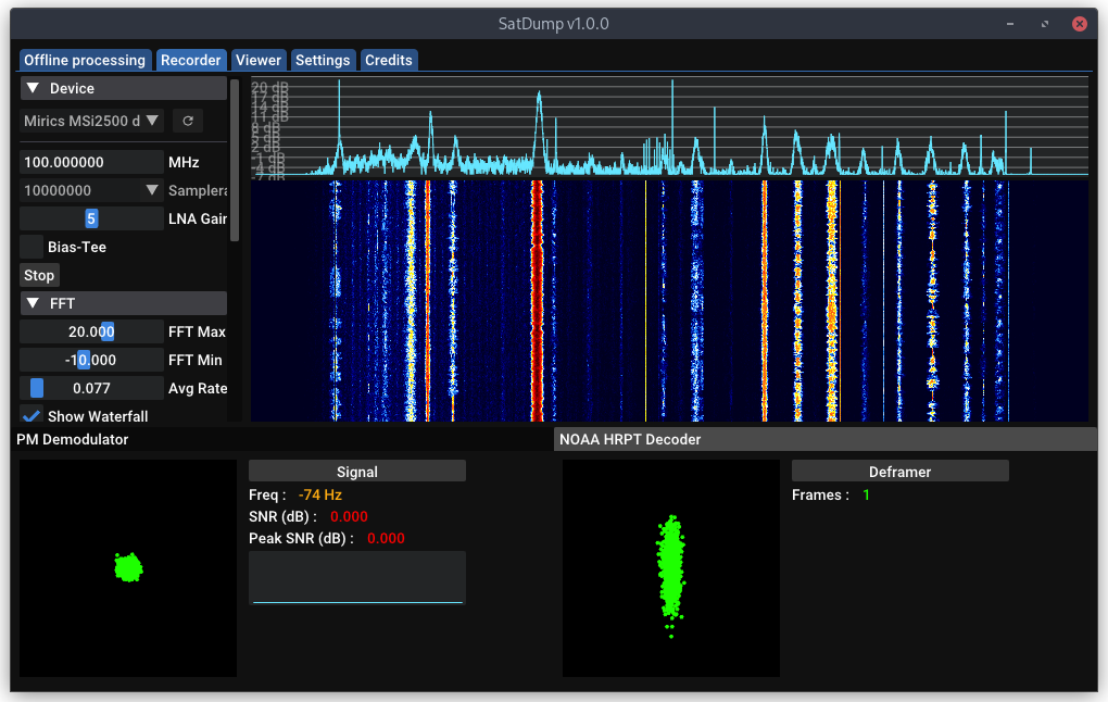
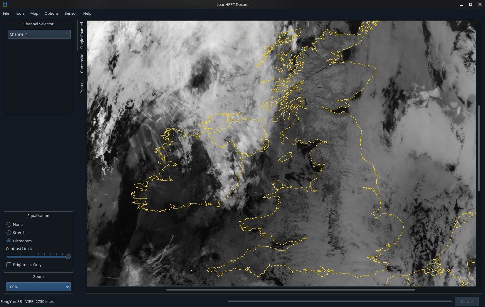
Over on Reddit u/Xerbot has posted about the release of his new software called "LeanHRPT". When combined with a software defined radio, this software can be used to decode and view HRPT weather satellite images received from satellites such as NOAA, Meteor, MetOp and FengYun. We note that unlike APT and LRPT weather satellite signals which transmit in the VHF bands, HRPT signals are generally at ~1.70 GHz and require a motorized or hand tracked satellite dish to receive. u/Xerbot writes:
LeanHRPT is a flexible, easy to use and powerful set of tools for the manipulation of HRPT data (maybe I could be convinced to add LRPT support).
When used properly LeanHRPT Decode can generate (almost) L1B data usable in actual land/weather observation, or just pretty images :)
The LeanHRPT project also contains LeanHRPT Demod, as you probably guessed, a HRPT demodulator. It features an incredibly high sensitivity as well as being able to do both realtime (through SoapySDR) and offline demodulation (baseband).
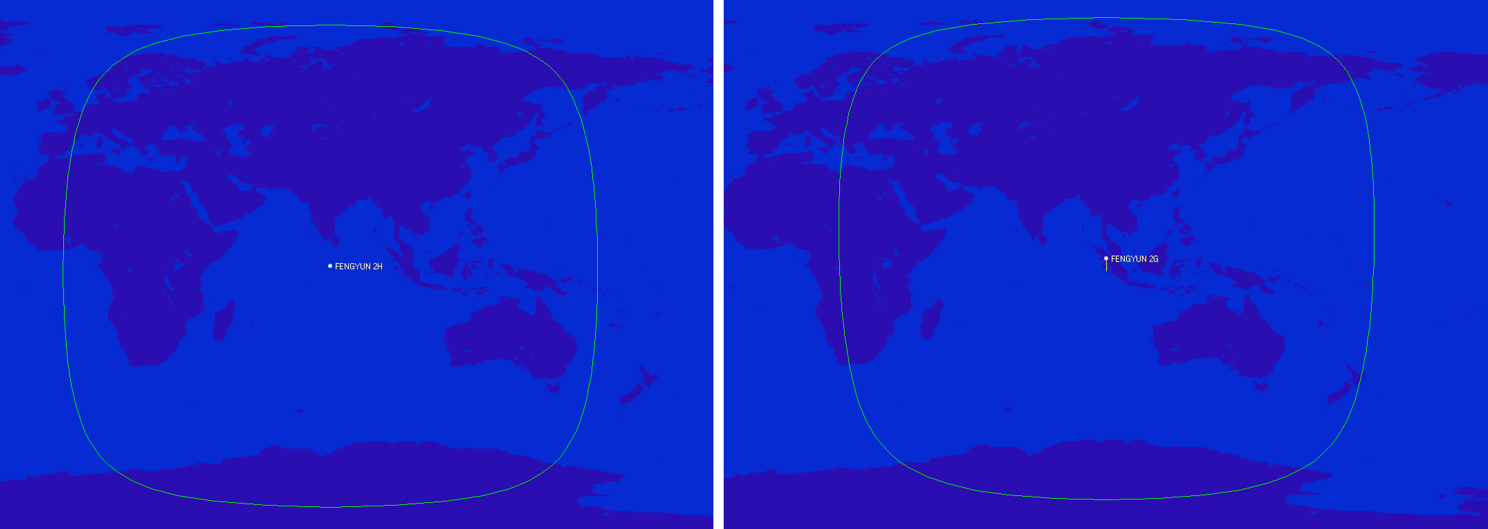
Back in November 2020 we posted about the release of a decoder for the FengYun line of geostationary weather satellites which provide full disk images of the Earth and are positioned to cover parts of Europe, Africa, the Middle East, Asia, Russia, and Australia. Back then only a few people had attempted decoding this, and it was believed that a 120cm satellite dish or larger would be required.
We do note that u/Harrison_Clark55's image appears to be missing a few lines of data, and they are based in Australia where the elevation of FY-2G could be quite high depending on what side of the continent they are on. So it's possible that receivers in lower elevations may still require a larger dish size to work.
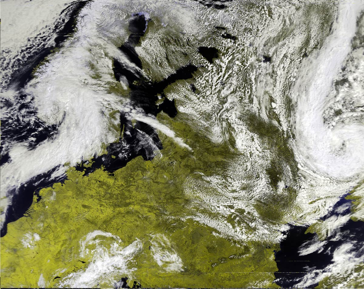
Full Disk FY-2G image received by u/Harrison_Clark55 (see the Reddit post for full resolution image)
The FengYun-2 line of weather satellites are the Chinese equivalents to GOES, and they are positioned to cover parts of Europe, Africa, the Middle East, Asia, Russia, and Australia. So this is another geostationary weather satellite now available to Europeans which broadcasts in the L-Band at 1687.5 MHz. And unlike the weaker GOES-13 L-Band downlink, the FengYun-2 downlink is much stronger which means that reception with a 120cm satellite dish should be possible. We note that it has not yet been confirmed if the typical 90-100 cm WiFi dishes used with GOES-16 and 17 will be big enough to work. @aang254 writes:
Yesterday I successfully decoded the S-VISSR downlink from FengYun-2H thanks to a recording by @MartanBlaho. It is stronger than PDR on EWS-G1 (see Zbychu's signal https://twitter.com/ZSztanga/status/1329801728162754560…) meaning it should (untested) be doable with a 120cm (or smaller but no confirmation again) dish instead of 180cm.
It covers parts of Europe, Russia and down to Australia. FY-2G and FY-2E (no confirmation for this one yet) are also decodable in the same way. I released an early decoder, that currently is not suitable for automated setups but allows getting images already. A later version (that should come soon-ish) will allow live decoding / autonomous setups in a similar fashion to other satellites.
Also, the res is 2km/px on VIS and 8km/px on IR, so half that of GOES-13 with similar-ish coverage (Europe is less visible though).
(also forgot to say but the bandwidth is under 2Mhz, allowing a rtlsdr to be used)
Gave a go at a FengYun-2H animation with the data recorded by @MartanBlaho.
Sadly some scans focus only on the northen hemisphere but it still turned fine!
Visible channel pic.twitter.com/9FcZlD9oYi
MetOp and FengYun-3 are both polar orbiting satellites that beam back high resolution weather satellite images. Unlike the NOAA polar orbiting satellites which transmit both the easy to receive APT and more advanced HRPT signal, these only transmit a HRPT signal at ~1.70 GHz, so a satellite dish and motorized tracking mount (or hand tracked) is required. You will also need an SDR capable of receiving over 3 MHz bandwidth such as an Airspy Mini or R2. Alan writes:
I recently got FengYun decoding working after the release of my MetOp decoder a while ago. Since gr-hrpt wasn't usable for Windows user without some major hassle, I made some standalone decoders (Windows builds included in the repo) for both MetOp and FengYun.
Decoding is done by first demodulating with the included flowcharts or @petermeteor's, then processed through the decoder which does Viterbi / Differential decoding. The output then needs to be deframed by MetFy3x or any other software that can do so.
FY-3B HRPT decoded with @aang254 's new decoder. I have to train at tracking a little more for the FY! Also used CLAHE to help the contrast. pic.twitter.com/dZ4ACNOBry
Thank you to @Derek33197785 for writing in and highlighting @aang254's work on gr-hrpt, a GNU Radio 3.8 port of HRPT blocks from gr-noaa and other projects. These blocks are for decoding the HRPT signal from weather satellites like NOAA, METEOR, MetOP, and soon FengYun-3. @Derek33197785 writes to us:
[@aang254] made a custom HRPT decoder and ported HRPT blocks for NOAA, METEOR and MetOp to work with gnuradio 3.8 on Linux. Right now it is the only free and open source decoder for MetOp (that works), and he also thinks about implementing FengYun support. I tested the decoder and it works great.
He's also working on extracting the full data from HRPT, not just the AVHRR/MSU-GS imagery but also all the telemetry and other instrument data.
HRPT is a high resolution weather satellite image signal that is broadcast from the same NOAA satellites that provide the more commonly received low resolution APT images at 137 MHz. HRPT is also broadcast by the FengYun-3, Metop and Meteor satellites. However, HRPT transmits at 1.7 GHz, so a high gain dish antenna with motorized tracking mount (or hand guided tracking), LNA and a high bandwidth SDR like an Airspy is required to receive it.
A Metop HRPT Weather Satellite Image (resolution reduced). See @Derek33197785's twitter post for the full resolution image.