Tagged: rtl-sdr

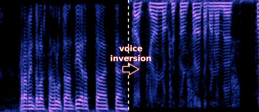
deinvert: A Voice Inversion Descrambler

Voice inversion scrambling is a simple and old security method used on analog radios to try and obscure conversations from being listened in on by people with scanners. It works simply by by moving the low frequencies higher and the high frequencies lower, or in other words inverting the audio. A descrambler is then required to recover the true audio, otherwise you will only hear garbled audio. Voice inversion provides little real security, as it is very simply to descramble, and many scanner radios already have descrambling features built in. These days most secure communications are digital and encrypted, but voice inversion scrambling is still available on many analog radios, and could still be in use by some users looking for protection against casual eavesdroppers.

Oona Räisänen (aka windytan) has recently released a simple program called ‘deinvert’ over on GitHub. This program is a descrambler that reads in a scrambled wav file and outputs a descrambled audio file. The audio file could be easily recorded with an RTL-SDR and rtl_fm, or a similar SDR.

Way back in 2013 she also did a post on her blog about voice inversion scrambling which is a good read for further information on how it works, and how to descramble it.

Voice Inversion Scrambling Spectrograph Example

Monitoring Train Railway Lines with an RTL-SDR and ATCS Monitor

Back in June Gus Gorman showed us via a YouTube tutorial and demo how to monitor ATCS (Advanced Train Control System) signals from trains. ATCS is found in the USA and is used for things like communications between trains, rail configuration data, train location data, speed enforcement, fuel monitoring, train diagnostics and general instructions and messages. Gus used an RTL-SDR and the ATCS Monitor software to decode the signals and give us a view of the current state of the railway line.

In his latest video Gus gives a better demonstration of the software by parking outside a train station so that he can receive many more signals from the trains. At the start of the video he shows the track view of BNSF trains, and then later switches over to the Union Pacific track view.

ATCS Monitor RTL-SDR at Omaha Train Station

Decoding the ALERT Protocol from a USGS Streamgage with an RTL-SDR

Over on his YouTube channel GusGorman402 has uploaded a video that shows how he was able to capture and decode data from a USGS (United States Geological Service) streamgage.

A streamgage is a sensor for streams and rivers that is used for measuring the amount of water flowing. In particular the ALERT (Automated Local Evaluation in Real-Time) streamgages are designed for the warning of flooding. The ALERT streamgages are wireless with some transmitting data upwards to the GOES-15 geosynchronous satellite with a cross Yagi and some transmitting locally via a standard Yagi. Gus shows if you’re close to a streamgage antenna then you can still receive the signal on the ground with an RTL-SDR. Gus also mentions that all streamgages in his area are slowly being converted to satellite uplink.

His first video simply shows the RTL-SDR receiving a Streamgage satellite uplink signal at 400 MHz. In his second video he moves to a streamgage with terrestrial link at 170 MHz and shows that the data can actually be decoded into a binary string using minimodem. Another program called udfc-node can then be used to turn the data into a human readable format. The binary packets consist of an address that identifies the particular streamgage, and some data that describes the current level of the stream and how much precipitation it has counted.

USGS Streamgage GOES-15 Uplink RTL-SDR Capture

USGS Streamgage 170MHz RTL-SDR decode

3D Printing a V-Dipole Bracket

Over on his YouTube channel user Tysonpower has uploaded a video that shows how to make a V-Dipole antenna. Back in March we posted about the V-Dipole which Adam 9A4QV first described. A V-Dipole is a simple antenna that normally consists of two metal rods, a terminal block and coax cable. It is particularly effective for reception of low Earth orbit satellites like the NOAA and Meteor M2 weather image satellites with an RTL-SDR or other similar SDR.

In his video Tysonpower shows how to build a slightly more rugged version using a 3D printed part instead of a terminal block. Aluminum welding rods are used for the elements. The 3D printed part ensures that the correct 120 degree ‘V’ angle is maintained and also provides a means for mounting the antenna to a pole. The 3D printing STL files are available on Thingiverse. Note that the video is in German, but English subtitles are available.

Note that we will also have a dipole antenna capable of being used as a V-Dipole available in our store in a few weeks time.

[EN subs] Bau einer V-Dipole Antenne - 3D Druck für mehr Genauigkeit und Stabilität

Nongles.com N3 RTL-SDR Available in our Store

Late last year the ThumbNet team announced their custom RTL-SDR dongle which they named the “Nongles N3”. This is a standard R820T2 RTL-SDR, but with some interesting additional features. Some of the changes they made include:

  • Shielding can on the PCB
  • Thick rugged metal case
  • F-Type connector
  • External 5V power input
  • Low noise PCB design

As explained in our previous reviews (prototype review, production review) the N3 is a rugged dongle, probably best suited to applications where the SDR could take a beating. The F-Type connector is also preferred by some people as it is fairly commonly used on TV equipment in most parts of the world. Shielding against local strong signals is also excellent due to its double shielding with a shielding can on the PCB and with the metal case.

Probably the most defining feature other than its ruggedness and low noise floor is that it can be optionally powered by 5V external power. So it could be used at the end of a very long active USB cable, with power provided locally. Or if very low power noise is desired, a linear power supply could be used.

We now have these N3 dongles available for purchase in our store. Please note that this is a commission sale, so the N3 will actually be shipped by the Nongles team in the USA once a week. The current price of the Nongles N3 is $33.5 USD + $4.5USD shipping in the USA, or $10 USD shipping worldwide.

Please Visit our Store

The ThumbNet N3
The ThumbNet N3
ThumbNet N3 with RFI Shield

(Almost) Receiving HRPT with the ADALM-PLUTO and a WiFi Grid Antenna

Over on YouTube user Tysonpower has uploaded a video showing how he was (almost) able to receive the HRPT signal from NOAA18 with an ADALM-PLUTO, LNA4ALL and a WiFi grid antenna.

Most readers will be familiar with the low resolution 137 MHz APT weather satellite images transmitted by the NOAA weather satellites. But NOAA 15, 18, 19 and well as Metop-A and Feng Yun satellites also transmit an HRPT (High Resolution Picture Transmission) signal up in the 1.7 GHz region. These HRPT images are much nicer to look at with a high 1.1 km resolution. If you follow @usa_satcom on Twitter you can see some HRPT images that he uploads every now and then.

However HRPT is quite difficult to receive and decode because the bandwidth is about 3 MHz so something with more bandwidth than an RTL-SDR is required. The signal also needs a ~1 meter or larger dish antenna as it is very weak, and you also need a motorized pointing system to track the satellite with the dish as it passes over.

Despite the difficulty in his video Tysonpower showed that he was able to at least receive a weak signal using a non-optimal 2.4 GHz WiFi grid dish antenna, LNA4ALL and his ADALM-PLUTO. The signal is far too weak to actually decode, but it’s still pretty surprising to receive it at all. In the future Tysonpower hopes to be able to improve his system and actually get some image decodes going. Note that the video is in German, but there are English subtitles available.

[EN subs] Empfang von HRPT mit dem ADALM-PLUTO SDR - NOAA18

Tracking Wildlife with TDOA Direction Finding and RTL-SDR Dongles

At the North-West University in South Africa Masters student SW Krüger submitted his dissertation titled “An inexpensive hyperbolic positioning system for tracking wildlife using off-the-shelf hardware” back in May of this year. Recently it was found online and can be viewed here (large pdf warning).

In his thesis Krüger explains his experiments with using RTL-SDR dongles to set up a very low cost wildlife monitoring system using TDOA (Time Difference of Arrival) techniques, and very low power beacons on the animal tags. TDOA is a difrection finding technique which involves using multiple receivers spread out over a region and calculating the difference in time from when the signal arrives at each receiver. With this information the position of the transmitter can be determined. Typically to do this the system clock in the computing hardware and OS needs to be synchronized as perfectly as possible between receivers, otherwise timing difference will cause huge errors in the position. Krüger uses synchronization bursts from a beacon, but notes that a real-time clock or GPS module could also be used for accurate time keeping.

In his experiment he set up two RTL-SDR receivers spaced 9 km apart and was able to obtain an accuracy of about 3.5m, which he writes is similar to other wildlife positioning systems that use tags with much higher power consumption. The computing hardware used at the RX station is a Raspberry Pi 3 powered by a 20W solar panel and batteries. There is also a wireless 3G modem for communications. The DSP software produced for the project is all open source and available on GitHub.

The RX System with RTL-SDR, Raspberry Pi, Mobile Broadband Modem, Power Supply and Solar Panel.

dopplerscript: Getting Doppler Updates from GPredict into GNU Radio

Thanks to Dave for submitting news of his recent release of his Python script called dopplerscript. This is a tool that can help people automate the reception and decoding of the Meteor M2 weather satellite in Linux with GNU Radio by providing a tool for automatic Doppler correction. He writes:

gr-gpredict-doppler is an out-of-tree gnuradio block for getting doppler updates from gpredict into a flowgraph. I’ve written a small python script (based on pyephem) that replaces gpredict for generating  the doppler updates. This script allows one to automate scripting the  reception of Meteor M2 satellite transmissions while compensating for the doppler shift.

dopplerscript is a command-line tool to input satellite doppler shifts into a gnuradio flowgraph. The doppler.py script replaces gpredict as the source for doppler frequency updates in gr-gpredict-doppler, making it easy to script satellite reception.

As low earth orbit satellites fly very quickly overhead, the signal will be affected by the doppler effect, thus shifting the frequency as it moves towards and away from you. Tools like this can be used to predict and compensate for this effect and thus providing better signal processing. Meteor M2 is a Russian weather satellite in low earth orbit which transmits digital LRPT weather satellite images that can be received with an RTL-SDR or other SDR.

An Example LRPT Image Received with an RTL-SDR from the Meteor-2 M2.
An Example LRPT Image Received with an RTL-SDR from Meteor M2.