[Ben Hilburn] the president of the [GNU Radio Project] has recently started a new podcast called [Signals and Bits]. If you were unaware, GNU Radio is the defacto open source framework for implementing digital signal processing code. Without it, many SDR programs that we take for granted may have never been developed as it is responsible for a lot of community DSP knowledge and algorithm development.
This podcast is scheduled for a new release every Wednesday and will be composed in an interview style focusing on a multitude of topics from Software Defined Radio to Spectrum Enforcement, Radio Astronomy and so much more.
In the first episode Ben interviews Harold Giddings AKA Corrosive of [Signals Everywhere] where they discuss the state of Software-Defined radio and how he got started with radio communications having come from an IT/Computer Networking background.
Ben has already pre-recorded several episodes which will ensure great content is always just around the corner. Ben would love it if you could also send feedback his way over on the [Signals and Bits Twitter] page.
Ben Hilburn President of GNU Radio (Left), Harold Giddings AKA Corrosive of Signals Everywhere (Right)
Thank you to Andrey for submitting news about the release of his new open source program called "rtlSpectrum". rtlSpectrum is a GUI for rtl_power, which allows you to scan a wide swath of bandwidth with an RTL-SDR dongle. The scan can then be plotted with rtlSpectrum, and peaks of activity can then be determined. Some of the features include:
load from .csv file produced by rtl_power
run rtl_power directly. it should be available in the $PATH
add multiple graphs for analysis
subtract one graph from another
save/export graph in the rtl_power based format
In particular, the ability to subtract one graph from another is useful for analyzing filters. Andrey has posted about doing this with rtlSpectrum, a noise source and an RTL-SDR V3 over on his blog (note that the blog is in Russian, so please use Google Translate if necessary). He notes how the dynamic range of the RTL-SDR is limited, so that the true blocking power of a filter cannot be determined, but it is enough to see the shape and frequency response.
On July 5 the Russian Meteor M N2-2 weather satellite was successfully launched into orbit and appears to be healthy. The LRPT weather camera signal is not yet broadcasting however, and we expect it to still take roughly 1-2 months before it begins (if all goes well) as satellites typically run through a long list of qualification tests before becoming operational. During this time there may be broadcasts of test patterns that can be caught. Meteor M N2-2 can currently be tracked in Orbitron and online at N2YO.
To try and dispel any confusion over the naming scheme, "Meteor M N2" is the currently operational LRPT satellite. "Meteor M N2-1" unfortunately failed in 2017 as it did not separate from the rocket. "Meteor M N2-2" is the new satellite which has just been successfully launched. Meteor M N2 and M N2-2 is often abbreviated as just "Meteor M2" and "Meteor M2-2". In the past there was Meteor M N1, but this satellite is no longer operational. We have upcoming launches for Meteor M2-3, M2-4, MP-1 and M3 to look forward to which are scheduled for 2020 and 2021.
Back on June 28 we posted about how Meteor M2 was experiencing orientation issues for a few days. Those issues appear to have been rectified now. Hopefully if M2 remains stable we'll have two Meteor LRPT weather satellites to receive alongside the three NOAA APT satellites.
If you're interested, there were also several other payloads onboard the rocket carrying M2-2, including a low cost Czech experimental cubesat called Lucky7 whose telemetry can be received in the amateur radio band at 437.525 MHz. There is an onboard camera too, but no details on how to receive it yet.
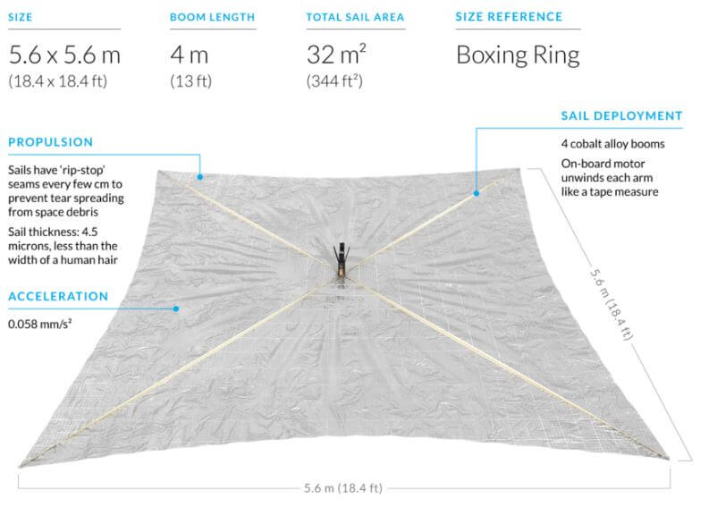
Lightsail-2 is a solar sail experiment which successfully launched on a Space-X Falcon Heavy on 25 June, and was released into orbit on July 2nd. A solar sail is a type of spacecraft that uses a large metallic foil to create propulsion via photons from the sun hitting it. Lightsail-2 is still undergoing testing, so it has not yet deployed it's solar sail, but recent updates indicate that it is healthy.
On board Lightsail-2 is a radio which is transmitting it's morse code beacon "WM9XPA" every 45 seconds at 437.025 MHz. This beacon should be able to be received with a handheld amateur radio 70cm Yagi and any radio such as an RTL-SDR. There is also an AX.25 telemetry data transmission, however although the beacon structure is available we are not aware of any publicly available decoding software.
One difficulty in receiving Lightsail-2 is that it is in an orbit inclination of only 24 degrees. So only locations with a latitude between 42 and -42 degrees will have a chance at receiving it. You can see the solar sail's current location at N2YO. Clicking on the 10-day predictions button will give you pass predictions for your location.
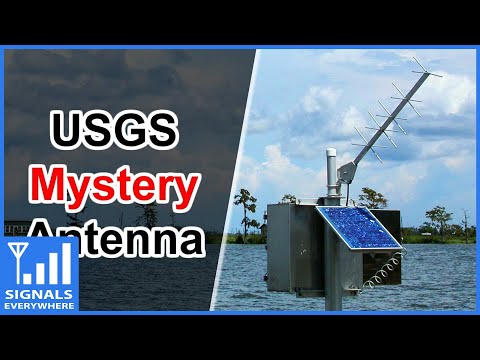
The United States Geological Service maintains over 8500 "Gaging stations" in bodies of water all over the country. Gaging stations are devices that are used to measure environmental data such as groundwater levels, discharge, water chemistry, and water temperature. What's interesting is that they all upload their data in real time to GOES satellites - the same satellites that we can use with an RTL-SDR to receive weather images of the entire earth. The data is then downlinked in the L-band to the USGS scientists via a protocol known as DCP (Data Collection Platform).
In the latest SignalsEverywhere video, Corrosive investigates how these stations work, and how we can receive the downlink at 1.68 GHz with a simple Inmarsat L-band antenna. While a fully functional decoder is not yet available, Corrosive notes that one called goes-dcs is currently being worked on.
USGS Gaging Station | Satellite Uplink to GOES and DCP Messages
In April, a stock research firm told clients that a Gulfstream V owned by Houston-based Occidental Petroleum Corp. had been spotted at an Omaha airport. The immediate speculation was that Occidental executives were negotiating with Buffett’s Berkshire Hathaway Inc. to get financial help in their $38 billion offer for rival Anadarko Petroleum Corp. Two days later, Buffett announced a $10 billion investment in Occidental.
There’s some evidence that aircraft-tracking can be used to get an early read on corporate news. A 2018 paper from security researchers at the University of Oxford and Switzerland’s federal Science and Technology department, tracked aircraft from three dozen public companies and identified seven instances of mergers-and-acquisitions activity. “It probably shouldn’t be your prime source of investing information, but as a feeder, as an alert of something else what might be going on, that’s where this work might be useful,” says Matthew Smith, a researcher at Oxford’s computer science department and one of the authors.
"Alternative data" collection firms like Quandl Inc. have services like "corporate aviation intelligence", where they use ADS-B data to keep tabs on private aircraft, then sell their data on to hedge funds and other investors who are hoping to gain an edge in the stock market.
Popular flight tracking sites that aggregate ADS-B data like FlightAware and FlightRadar24 censor data from private jets on their public maps upon the request of the owner, but it's not known if they continue to sell private jet data on to other parties. ADS-B Exchange is one ADS-B aggregator that promises to never censor flights, however the data is only free for non-commercial use. The value from using companies like Quandl is that they probably have a much more accurate database of who each private jet belongs to.
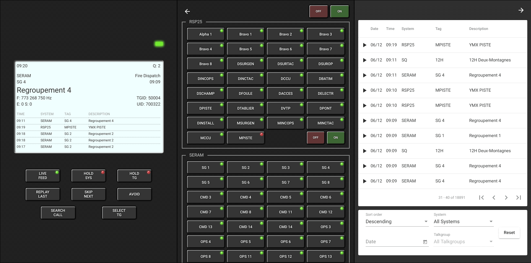
Trunk Recorder is an RTL-SDR compatible open source Linux app that records calls from Trunked P25 and SmartNet digital voice radio systems which are commonly used by Police and other emergency services in the USA. It can be used to set up a system that allows you to listen to previous calls at your leisure, however it does not have any UI for easy browsing.
Recently Chrystian Huot wrote in and wanted to share his new program called "Rdio Scanner", which is a nice looking UI for Trunk Recorder. Rdio Scanner uses the files generated by Trunk Recorder to create a web based interface that looks like a real hardware scanner radio. Some of the features include:
Built to act as a real police radio scanner
Listen to live calls queued to listen
Hold a single system or a single talkgroup
Select talkgroups to listen to when live feed is enabled
Russian weather satellite Meteor M2 is a popular reception target for RTL-SDR radio enthusiasts, as it allows you to receive high resolution images of the Earth. However, currently it appears to be exhibiting orientation issues, causing off center and skewed images and sometimes poor/no reception. Russian blog "aboutspacejornal", writes that the orientation of the satellite can sometimes be restored presumably by a reset command from Earth, but shortly after goes back into uncontrolled rotation.
These sorts of off-axis images were commonly received from the older decommissioned Meteor-M1 satellite, which woke up from the dead in 2015. The resurrection was speculated to be from the batteries shorting out, allowing power to directly flow from the solar panels while in full sunlight. These days Meteor-M1 is no longer transmitting.
Hopefully Meteor-M2 can be fixed, but if not, Meteor M2-2 is due to be launched on July 5 which should also have an LRPT signal that can be received easily with an RTL-SDR. Hopefully the launch is more successful than the November 2017 launch of Meteor M2-1 which unfortunately was a complete loss as it failed to separate from the rocket.